Grootebeek British Cemetery
Reningelst, Arrondissement Ieper, West Flanders, Belgium
About
-
- Cemetery ID:
Members have Contributed
Advertisement
Photos


Location Information: Grootebeek British Cemetery is located 8 km west of Ieper town centre on the Bellestraat, a road leading from the N308 connecting Ieper to Poperinge via Vlamertinge. From Ieper town centre the Poperingseweg (N308), is reached via Elverdingsestraat then directly over two small roundabouts in the J. Capronstraat. The Poperingseweg is a continuation of the J. Capronstraat and begins after a prominent railway level crossing. On reaching the village of Vlamertinge take the left hand turning onto the Bellestraat, after crossing the N38 Ieper Poperinge road the cemetery lies a further 5 km along the Bellestraat which changes its name to Vlamertingseweg. The site is on the right hand side of the road in the hamlet of Ouderdom.
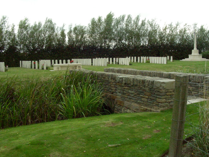
Historical Information: The village of Reninghelst was in Allied hands from the autumn of 1914 to the end of the First World War. From March 1915, Commonwealth burials were made in the churchyard, the churchyard extension and the new military cemetery, but in April 1918, in the Battles of the Lys, a new cemetery was made by field ambulances and fighting units near the hamlet of Ouderdom, on the Poperinghe-Wytschaete road. It was called at first Ouderdom Military Cemetery, but later Grootebeek British Cemetery, from the stream (Grootebeek, or Groote Kemmelbeek) which runs beside it. It was used at intervals until the end of September 1915 and it absorbed a small Indian cemetery made on the spot in April 1915. The cemetery contains 109 Commonwealth burials and commemorations of the First World War. One grave destroyed by shell fire is now represented by a special memorial, and another special memorial records the name of Pte J Lynn, VC, who was buried in Vlamertinghe Churchyard but whose grave was similarly destroyed. The two Second World War burials date from May 1940 and the withdrawal of the British Expeditionary Force ahead of the German advance. The cemetery was designed by W H Cowlishaw.
No. of Identified Casualties: 109
Location Information: Grootebeek British Cemetery is located 8 km west of Ieper town centre on the Bellestraat, a road leading from the N308 connecting Ieper to Poperinge via Vlamertinge. From Ieper town centre the Poperingseweg (N308), is reached via Elverdingsestraat then directly over two small roundabouts in the J. Capronstraat. The Poperingseweg is a continuation of the J. Capronstraat and begins after a prominent railway level crossing. On reaching the village of Vlamertinge take the left hand turning onto the Bellestraat, after crossing the N38 Ieper Poperinge road the cemetery lies a further 5 km along the Bellestraat which changes its name to Vlamertingseweg. The site is on the right hand side of the road in the hamlet of Ouderdom.
Historical Information: The village of Reninghelst was in Allied hands from the autumn of 1914 to the end of the First World War. From March 1915, Commonwealth burials were made in the churchyard, the churchyard extension and the new military cemetery, but in April 1918, in the Battles of the Lys, a new cemetery was made by field ambulances and fighting units near the hamlet of Ouderdom, on the Poperinghe-Wytschaete road. It was called at first Ouderdom Military Cemetery, but later Grootebeek British Cemetery, from the stream (Grootebeek, or Groote Kemmelbeek) which runs beside it. It was used at intervals until the end of September 1915 and it absorbed a small Indian cemetery made on the spot in April 1915. The cemetery contains 109 Commonwealth burials and commemorations of the First World War. One grave destroyed by shell fire is now represented by a special memorial, and another special memorial records the name of Pte J Lynn, VC, who was buried in Vlamertinghe Churchyard but whose grave was similarly destroyed. The two Second World War burials date from May 1940 and the withdrawal of the British Expeditionary Force ahead of the German advance. The cemetery was designed by W H Cowlishaw.
No. of Identified Casualties: 109
Nearby cemeteries

Reningelst, Arrondissement Ieper, West Flanders, Belgium
- Total memorials57
- Percent photographed100%
- Percent with GPS4%

Reningelst, Arrondissement Ieper, West Flanders, Belgium
- Total memorials22
- Percent photographed82%
- Percent with GPS5%

Reningelst, Arrondissement Ieper, West Flanders, Belgium
- Total memorials798
- Percent photographed31%
- Percent with GPS5%

Dikkebus, Arrondissement Ieper, West Flanders, Belgium
- Total memorials1k+
- Percent photographed95%
- Percent with GPS2%
- Added: 5 Sep 2004
- Find a Grave Cemetery ID: 1992237

Cemetery Photos
This is a carousel with slides. Use Next and Previous buttons to navigate, or jump to a slide with the slide dots. Use Escape keyboard button or the Close button to close the carousel.


Success
Uploading...
Waiting...
Failed
This photo was not uploaded because this cemetery already has 20 photos
This photo was not uploaded because you have already uploaded 5 photos to this cemetery
This photo was not uploaded because you have already uploaded 5 photos to this cemetery
Invalid File Type
Birth and death years unknown.
1 photo picked...
2 photos picked...
Uploading 1 Photo
Uploading 2 Photos
1 Photo Uploaded
2 Photos Uploaded
Size exceeded
Too many photos have been uploaded
"Unsupported file type"
• ##count## of 0 memorials with GPS displayed. Double click on map to view more.No cemeteries found