Southwest Burying Yard
Surry, Cheshire County, New Hampshire, USA
Levi Hancock gave this land for a burying place about 1800. At a town meeting June 3, 1812, a committee was appointed to see about fencing the three burying yards.
They reported:
"First, we think proper to fence the southwest burying ground with stone.
Second, the South burying ground likewise.
Third, the one by the meeting house we think proper to repair it by new posts and nailing on the boards for the present year."
Nathan Hayward
Eli Dort
Levi Hancock
Committee.
In another place is it described as belonging to Levi Hancock and was "on the old road south of Oliver Wright's barn" and was bounded "beginning at the southwest corner of the wall now built, running westerly seven rods as the wall is now built to a bar post with stones about it; thence north to a stake and stones five rods; thence east five rods to the wall on the road; thence southerly as the wall now runs six rods and a half to the first mentioned bound."
Levi Hancock bid off the job of fencing the yard at .75c per rod, the same to be finished by Oct. 1, 1812. Owing to the condition of the ground the wall around this yard is in need of repair.
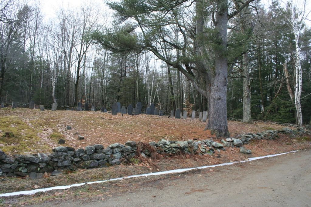
This yard is in the southwest part of the town, near Keene and Westmoreland lines. From it can be seen Monadnock over Beech Hill, and in the east the long line of blue hills in Nelson. One house can be seen perhaps one half mile away, and a set of buildings near the foot of Monadnock. The lot is about ten rods square, enclosed on all sides by a stone wall, and a gate is at the entrance near the road.
On the outside of the wall and running all around the yard except the north side, is a row of fine trees, birch, maple, ash, oak, black cherry and three beautiful white ash.
Two larch, a pine and some small willows are inside. In summer the ground is pink with cinnamon roses, and there are also many old fashioned red roses and some heath. The red and white clover grows luxuriantly.
Nearly all the stone in this yard are of white marble; the first burials of which any stones make records are those of Dr. Noah Fuller and his wife in 1809.
The southeast part of the yard for about four rods square is full of graves, thirty of more, with no stones; these are Irishmen who died or were killed while the railroad was being built to the Summit. There were so many quarrels and fights that the Militia were stationed here for some months.
About a dozen graves in this yard are unknown and unmarked; some unmarked graves have been identified by Benjamin Crosby, and most of the graves have stones.
Levi Hancock gave this land for a burying place about 1800. At a town meeting June 3, 1812, a committee was appointed to see about fencing the three burying yards.
They reported:
"First, we think proper to fence the southwest burying ground with stone.
Second, the South burying ground likewise.
Third, the one by the meeting house we think proper to repair it by new posts and nailing on the boards for the present year."
Nathan Hayward
Eli Dort
Levi Hancock
Committee.
In another place is it described as belonging to Levi Hancock and was "on the old road south of Oliver Wright's barn" and was bounded "beginning at the southwest corner of the wall now built, running westerly seven rods as the wall is now built to a bar post with stones about it; thence north to a stake and stones five rods; thence east five rods to the wall on the road; thence southerly as the wall now runs six rods and a half to the first mentioned bound."
Levi Hancock bid off the job of fencing the yard at .75c per rod, the same to be finished by Oct. 1, 1812. Owing to the condition of the ground the wall around this yard is in need of repair.
This yard is in the southwest part of the town, near Keene and Westmoreland lines. From it can be seen Monadnock over Beech Hill, and in the east the long line of blue hills in Nelson. One house can be seen perhaps one half mile away, and a set of buildings near the foot of Monadnock. The lot is about ten rods square, enclosed on all sides by a stone wall, and a gate is at the entrance near the road.
On the outside of the wall and running all around the yard except the north side, is a row of fine trees, birch, maple, ash, oak, black cherry and three beautiful white ash.
Two larch, a pine and some small willows are inside. In summer the ground is pink with cinnamon roses, and there are also many old fashioned red roses and some heath. The red and white clover grows luxuriantly.
Nearly all the stone in this yard are of white marble; the first burials of which any stones make records are those of Dr. Noah Fuller and his wife in 1809.
The southeast part of the yard for about four rods square is full of graves, thirty of more, with no stones; these are Irishmen who died or were killed while the railroad was being built to the Summit. There were so many quarrels and fights that the Militia were stationed here for some months.
About a dozen graves in this yard are unknown and unmarked; some unmarked graves have been identified by Benjamin Crosby, and most of the graves have stones.
Nearby cemeteries
Surry, Cheshire County, New Hampshire, USA
- Total memorials8
- Percent photographed0%
- Percent with GPS0%

Surry, Cheshire County, New Hampshire, USA
- Total memorials1k+
- Percent photographed87%
- Percent with GPS2%

Westmoreland, Cheshire County, New Hampshire, USA
- Total memorials38
- Percent photographed92%
- Percent with GPS3%

Walpole, Cheshire County, New Hampshire, USA
- Total memorials75
- Percent photographed64%
- Percent with GPS3%
- Added: 14 Dec 2010
- Find a Grave Cemetery ID: 2380963

Cemetery Photos
This is a carousel with slides. Use Next and Previous buttons to navigate, or jump to a slide with the slide dots. Use Escape keyboard button or the Close button to close the carousel.
Success
Uploading...
Waiting...
Failed
This photo was not uploaded because this cemetery already has 20 photos
This photo was not uploaded because you have already uploaded 5 photos to this cemetery
This photo was not uploaded because you have already uploaded 5 photos to this cemetery
Invalid File Type
Birth and death years unknown.
1 photo picked...
2 photos picked...
Uploading 1 Photo
Uploading 2 Photos
1 Photo Uploaded
2 Photos Uploaded
Size exceeded
Too many photos have been uploaded
"Unsupported file type"
• ##count## of 0 memorials with GPS displayed. Double click on map to view more.No cemeteries found