Cedar Creek Cemetery
Also known as Old Cedar Cemetery
Red River County, Texas, USA
About
-
- Cemetery ID:
Members have Contributed
Advertisement
Photos


From Lydia in Red River Co., TX - Go South or West on 44 until you see CR 4640. Turn Left onto 4640. Follow 4640 until you see 4650 - follow 4650 to the end - the cemetery is at the end of 4650.
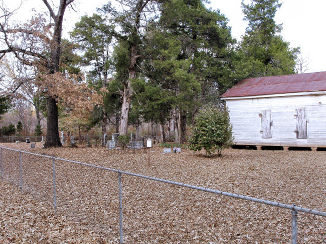
This cemetery is located in the southeast quadrant of Red River County, Texas. GPS COORDINATES: Datum WGS84: 33 Deg 23.523N, 94 Deg 45.007W, El 329 ft. From Lydia take FM 44 southwest for 8/10 mile to the intersection with CR 4640. Take CR 4640 left or south for 6.2 miles and following many turns, you will arrive at the intersection with CR 4650. Take CR 4650 left or north and after 1.8 miles you will arrive at the cemetery at the very end of the road. A deed transaction dated 2 Aug 1883 from G. I. Finney Et Ux to Cedar Creek Cemetery, filed in Book CH Vol 25 Page 507 on 11 Jul 1893, transferred 1 acre of the John Sweitzer Survey to the Annona Methodist Episcopal Church. On 7 Aug 1939 an additional 2 acres was deeded by Sallie E. Eitel of the same survey and it was filed on 7 Mar 1956 in Book CH Vol 204 Page 638. The oldest marked burial is that of Martha Jane Rosser Duke who died on 10 Jan 1852. This cemetery was surveyed by Lawrence and Sue Dale on 15 Feb 1999. We made the trip to this site on 3 Feb 2003 to get the GPS Coordinates. We also did a re-walk of the cemetery adding new burials and noting marker changes. As of 31 Dec 2004 this cemetery had 211 documented burials. All information for this cemetery is from the books ‘Burial, Cemetery and Death Records for Red River County, Texas' by Lawrence and Sue Dale, Copyright © 2005.
From Lydia in Red River Co., TX - Go South or West on 44 until you see CR 4640. Turn Left onto 4640. Follow 4640 until you see 4650 - follow 4650 to the end - the cemetery is at the end of 4650.
This cemetery is located in the southeast quadrant of Red River County, Texas. GPS COORDINATES: Datum WGS84: 33 Deg 23.523N, 94 Deg 45.007W, El 329 ft. From Lydia take FM 44 southwest for 8/10 mile to the intersection with CR 4640. Take CR 4640 left or south for 6.2 miles and following many turns, you will arrive at the intersection with CR 4650. Take CR 4650 left or north and after 1.8 miles you will arrive at the cemetery at the very end of the road. A deed transaction dated 2 Aug 1883 from G. I. Finney Et Ux to Cedar Creek Cemetery, filed in Book CH Vol 25 Page 507 on 11 Jul 1893, transferred 1 acre of the John Sweitzer Survey to the Annona Methodist Episcopal Church. On 7 Aug 1939 an additional 2 acres was deeded by Sallie E. Eitel of the same survey and it was filed on 7 Mar 1956 in Book CH Vol 204 Page 638. The oldest marked burial is that of Martha Jane Rosser Duke who died on 10 Jan 1852. This cemetery was surveyed by Lawrence and Sue Dale on 15 Feb 1999. We made the trip to this site on 3 Feb 2003 to get the GPS Coordinates. We also did a re-walk of the cemetery adding new burials and noting marker changes. As of 31 Dec 2004 this cemetery had 211 documented burials. All information for this cemetery is from the books ‘Burial, Cemetery and Death Records for Red River County, Texas' by Lawrence and Sue Dale, Copyright © 2005.
Nearby cemeteries

Bowie County, Texas, USA
- Total memorials167
- Percent photographed89%
- Percent with GPS17%

Lydia, Red River County, Texas, USA
- Total memorials6
- Percent photographed83%
- Percent with GPS0%

Lydia, Red River County, Texas, USA
- Total memorials511
- Percent photographed96%
- Percent with GPS3%

Hodgson, Bowie County, Texas, USA
- Total memorials362
- Percent photographed89%
- Percent with GPS72%
- Added: 1 Jan 2000
- Find a Grave Cemetery ID: 2801

Cemetery Photos
This is a carousel with slides. Use Next and Previous buttons to navigate, or jump to a slide with the slide dots. Use Escape keyboard button or the Close button to close the carousel.


Success
Uploading...
Waiting...
Failed
This photo was not uploaded because this cemetery already has 20 photos
This photo was not uploaded because you have already uploaded 5 photos to this cemetery
This photo was not uploaded because you have already uploaded 5 photos to this cemetery
Invalid File Type
Birth and death years unknown.
1 photo picked...
2 photos picked...
Uploading 1 Photo
Uploading 2 Photos
1 Photo Uploaded
2 Photos Uploaded
Size exceeded
Too many photos have been uploaded
"Unsupported file type"
• ##count## of 0 memorials with GPS displayed. Double click on map to view more.No cemeteries found