Lerado Cemetery
Reno County, Kansas, USA
About
-
- Cemetery ID:
Members have Contributed
Advertisement
Photos


Coleen Parry
4277 NW 70th Ave.
Cunningham, Ks 67035
[email protected]
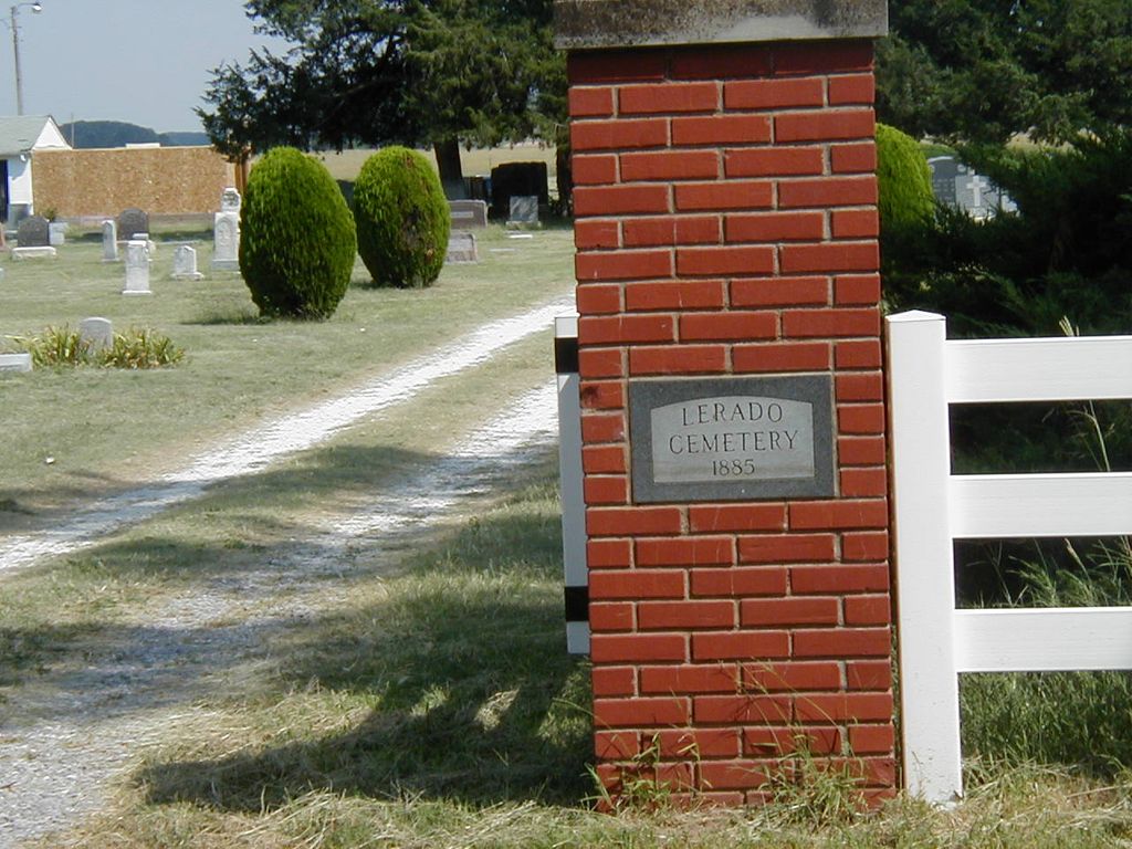
The Lerado Cemetery is a well cared for moderately sized rural prairie cemetery accessed from S. Lerado Rd., a sandy dirt road. It has a white vinyl fence which runs along the front of the cemetery with old large shade trees spaced along the fencing. Most of the cemetery is without a shade canopy but there are large trees scattered through out the cemetery including both deciduous and evergreen with large evergreen shrubs planted along some of the internal cemetery roads. The ground is level for walking but one should watch out for the occasional animal dug hole or depression. There is a maintenance building within the cemetery along with a small shelter, benches and a shelter covered cemetery map. There are 6 internal roads which run east and west (perpendicular to S. Lerado Rd.) and several crossroads running north and south which divide up the 6 sections, A - F. If you are looking for a grave from the cemetery map, it helps to orient yourself first with the 6 east/west internal roads to cut down on confusion. Not all of these 6 internal roads open out onto S. Lerado Rd.
Coleen Parry
4277 NW 70th Ave.
Cunningham, Ks 67035
[email protected]
The Lerado Cemetery is a well cared for moderately sized rural prairie cemetery accessed from S. Lerado Rd., a sandy dirt road. It has a white vinyl fence which runs along the front of the cemetery with old large shade trees spaced along the fencing. Most of the cemetery is without a shade canopy but there are large trees scattered through out the cemetery including both deciduous and evergreen with large evergreen shrubs planted along some of the internal cemetery roads. The ground is level for walking but one should watch out for the occasional animal dug hole or depression. There is a maintenance building within the cemetery along with a small shelter, benches and a shelter covered cemetery map. There are 6 internal roads which run east and west (perpendicular to S. Lerado Rd.) and several crossroads running north and south which divide up the 6 sections, A - F. If you are looking for a grave from the cemetery map, it helps to orient yourself first with the 6 east/west internal roads to cut down on confusion. Not all of these 6 internal roads open out onto S. Lerado Rd.
Nearby cemeteries

Langdon, Reno County, Kansas, USA
- Total memorials5
- Percent photographed100%
- Percent with GPS0%

Langdon, Reno County, Kansas, USA
- Total memorials613
- Percent photographed86%
- Percent with GPS0%

Pretty Prairie, Reno County, Kansas, USA
- Total memorials612
- Percent photographed96%
- Percent with GPS2%

Arlington, Reno County, Kansas, USA
- Total memorials10
- Percent photographed80%
- Percent with GPS0%
- Added: 1 Jan 2000
- Find a Grave Cemetery ID: 92880

Cemetery Photos
This is a carousel with slides. Use Next and Previous buttons to navigate, or jump to a slide with the slide dots. Use Escape keyboard button or the Close button to close the carousel.


Success
Uploading...
Waiting...
Failed
This photo was not uploaded because this cemetery already has 20 photos
This photo was not uploaded because you have already uploaded 5 photos to this cemetery
This photo was not uploaded because you have already uploaded 5 photos to this cemetery
Invalid File Type
Birth and death years unknown.
1 photo picked...
2 photos picked...
Uploading 1 Photo
Uploading 2 Photos
1 Photo Uploaded
2 Photos Uploaded
Size exceeded
Too many photos have been uploaded
"Unsupported file type"
• ##count## of 0 memorials with GPS displayed. Double click on map to view more.No cemeteries found