Greenwood Cemetery
Also known as Carman Greenwood Cemetery
Carman, Pembina Valley Census Division, Manitoba, Canada
About
-
- www.carmandufferinheritage.ca/local%20heritage/cemeteries/cemcarman.html
- [email protected]
- +1-204-745-2443
-
Office Address
12 2nd Ave SW
Box 160
Carman, Manitoba
R0G 0J0 Canada - Cemetery ID:
-
Additional information
Located just south of the town of Carman on the east side of Main Street South (aka Provincial Highway 3).
Sign the visitors' book at the small building on the centre lane and access the QR code for a guide.
The cemetery is co-located with Our Lady of Mount Carmel Catholic Cemeterywhich occupies the southwest corner of the property; i.e., the south side of the centre lane within the cemetery, the part between the highway and eastward to the grotto and a set of tall bushes. Efforts are being made to transfer memorials that were catalogued in the wrong one.
Members have Contributed
Advertisement
Photos

Greenwood, owned and managed by the Town of Carman, is the largest cemetery in Carman and the RM of Dufferin. It is a time capsule of local heritage. Here, one will find the names of some of the earliest settlers in the Boyne area. Note, in particular, markers on the Kennedy family plot. Retrieved from the river bank near the former Kennedy burial site, the original markers were moved to their present location where they were placed next to a later commemorative stone.
Also on the markers are the names of other notable pioneer families, businessmen and politicians such as
Campbell, Clandening, Doyle, Roblin or Watson and for sportsmen, musicians and other leaders who left their mark on local heritage.
The Dufferin History notes that: "By 1890, there was a pressing need for a cemetery in Carman. A public meeting was held in the Presbyterian Church and a committee was appointed to look into the matter. They were empowered to purchase three acres of land '…in the most convenient place, at the lowest possible price, and on the most favourable terms and to act as trustees and exercise such powers as conferred by Sec 145 of Cap9 of the consolidated Statues of Manitoba'."
From this initial action, a cemetery was laid out in the south end of Carman and named Greenwood Cemetery. On August 15, 1891, the RM of Dufferin passed a motion granting $50 for the purpose of fencing the cemetery. The parishoners of the local Our Lady of Mount Carmel Roman Catholic Church later established a dedicated Roman Catholic burial ground on the south side of the cemetery.
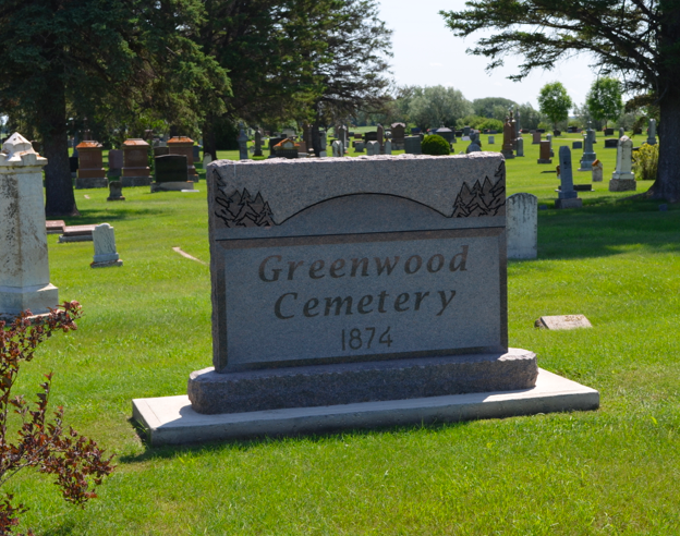
Note: Burials had been made at this location prior to the designation of the site as a cemetery. The earliest date that can be read on the early markers is 1874, hence the date on the Greenwood sign at the gates.
The cemetery is laid out in numbered rows with early graves at the west end of the cemetery (i.e., nearest the highway). There is a large number of pillar/column markers and imposing family monuments in the earlier northwest and central areas of the cemetery. A columbarium, with vaults for cremation urns, is located in the southeast section. Newer sections on that same southeast portion feature a trend of providing solid cement foundation pads on which to place rows of gravestones and enable easier maintenance.
(Source: Carman/Dufferin Municipal Heritage Committee [Adapted])
An early cemetery was located on the Samuel Kennedy homestead on SW29-06-04-W1 [near 49.504560,-97.976309], near where the Missouri Trail crossed the Boyne River. The first recorded burials were in 1875 when two of the Kennedy children died. In the same year, Mrs. John McCullough and her daughter, Mary, were buried there after succumbing to typhoid fever. Names of other families who used the cemetery were: Stewart, Olson and Moyle. The last burial at the site was in 1889.
In later years, grave markers began to crumble into the river. The markers were retrieved, stored in the Carman Granite workshop for some years and finally placed in Greenwood Cemetery on the Kennedy grave.
Dominion Land Survey coordinates: LSD05-19-06-04-W1
Carman is designated as a Town and has its own administration, independent of the surrounding Rural Municipality of Dufferin, for which it is also the administrative centre.
A part of the town's story and those of its inhabitants from the early days of European settlement through roughly 1967 is told in the volume "Up to Now - A Story of Dufferin and Carman"and a related volume entitled "The Rural Municipality of Dufferin 1880-1980".
Free digital versions of these and many other Manitoba local history books can be found online in the University of Manitoba Digital Collections. There is also a list of such books organized by district and town name on the Manitoba Historical Society's website on their page entitled "Finding Aid: Manitoba Local History Books".
A list of burials in this cemetery is available from the Manitoba Genealogical Society (reference #0492), transcribed by a member or members in 1988-1989. Also available to MGS members is a searchable online database named the "MGS Manitoba Name Index" (or MANI). Some additional information is contained in the 1996 MGS publication "Carved in Stone: Manitoba Cemeteries and Burial Sites" (revised edition, Special Projects Publication, 106 pages).
Greenwood, owned and managed by the Town of Carman, is the largest cemetery in Carman and the RM of Dufferin. It is a time capsule of local heritage. Here, one will find the names of some of the earliest settlers in the Boyne area. Note, in particular, markers on the Kennedy family plot. Retrieved from the river bank near the former Kennedy burial site, the original markers were moved to their present location where they were placed next to a later commemorative stone.
Also on the markers are the names of other notable pioneer families, businessmen and politicians such as
Campbell, Clandening, Doyle, Roblin or Watson and for sportsmen, musicians and other leaders who left their mark on local heritage.
The Dufferin History notes that: "By 1890, there was a pressing need for a cemetery in Carman. A public meeting was held in the Presbyterian Church and a committee was appointed to look into the matter. They were empowered to purchase three acres of land '…in the most convenient place, at the lowest possible price, and on the most favourable terms and to act as trustees and exercise such powers as conferred by Sec 145 of Cap9 of the consolidated Statues of Manitoba'."
From this initial action, a cemetery was laid out in the south end of Carman and named Greenwood Cemetery. On August 15, 1891, the RM of Dufferin passed a motion granting $50 for the purpose of fencing the cemetery. The parishoners of the local Our Lady of Mount Carmel Roman Catholic Church later established a dedicated Roman Catholic burial ground on the south side of the cemetery.
Note: Burials had been made at this location prior to the designation of the site as a cemetery. The earliest date that can be read on the early markers is 1874, hence the date on the Greenwood sign at the gates.
The cemetery is laid out in numbered rows with early graves at the west end of the cemetery (i.e., nearest the highway). There is a large number of pillar/column markers and imposing family monuments in the earlier northwest and central areas of the cemetery. A columbarium, with vaults for cremation urns, is located in the southeast section. Newer sections on that same southeast portion feature a trend of providing solid cement foundation pads on which to place rows of gravestones and enable easier maintenance.
(Source: Carman/Dufferin Municipal Heritage Committee [Adapted])
An early cemetery was located on the Samuel Kennedy homestead on SW29-06-04-W1 [near 49.504560,-97.976309], near where the Missouri Trail crossed the Boyne River. The first recorded burials were in 1875 when two of the Kennedy children died. In the same year, Mrs. John McCullough and her daughter, Mary, were buried there after succumbing to typhoid fever. Names of other families who used the cemetery were: Stewart, Olson and Moyle. The last burial at the site was in 1889.
In later years, grave markers began to crumble into the river. The markers were retrieved, stored in the Carman Granite workshop for some years and finally placed in Greenwood Cemetery on the Kennedy grave.
Dominion Land Survey coordinates: LSD05-19-06-04-W1
Carman is designated as a Town and has its own administration, independent of the surrounding Rural Municipality of Dufferin, for which it is also the administrative centre.
A part of the town's story and those of its inhabitants from the early days of European settlement through roughly 1967 is told in the volume "Up to Now - A Story of Dufferin and Carman"and a related volume entitled "The Rural Municipality of Dufferin 1880-1980".
Free digital versions of these and many other Manitoba local history books can be found online in the University of Manitoba Digital Collections. There is also a list of such books organized by district and town name on the Manitoba Historical Society's website on their page entitled "Finding Aid: Manitoba Local History Books".
A list of burials in this cemetery is available from the Manitoba Genealogical Society (reference #0492), transcribed by a member or members in 1988-1989. Also available to MGS members is a searchable online database named the "MGS Manitoba Name Index" (or MANI). Some additional information is contained in the 1996 MGS publication "Carved in Stone: Manitoba Cemeteries and Burial Sites" (revised edition, Special Projects Publication, 106 pages).
Nearby cemeteries

Carman, Pembina Valley Census Division, Manitoba, Canada
- Total memorials298
- Percent photographed99%
- Percent with GPS1%
Pembina Valley Census Division, Manitoba, Canada
- Total memorials15
- Percent photographed0%
Pembina Valley Census Division, Manitoba, Canada
- Total memorials7
- Percent photographed0%
Pembina Valley Census Division, Manitoba, Canada
- Total memorials7
- Percent photographed0%
- Added: 28 Jun 2004
- Find a Grave Cemetery ID: 1987041

Cemetery Photos
This is a carousel with slides. Use Next and Previous buttons to navigate, or jump to a slide with the slide dots. Use Escape keyboard button or the Close button to close the carousel.

Success
Uploading...
Waiting...
Failed
This photo was not uploaded because this cemetery already has 20 photos
This photo was not uploaded because you have already uploaded 5 photos to this cemetery
This photo was not uploaded because you have already uploaded 5 photos to this cemetery
Invalid File Type
Birth and death years unknown.
1 photo picked...
2 photos picked...
Uploading 1 Photo
Uploading 2 Photos
1 Photo Uploaded
2 Photos Uploaded
Size exceeded
Too many photos have been uploaded
"Unsupported file type"
• ##count## of 0 memorials with GPS displayed. Double click on map to view more.No cemeteries found