Huts Cemetery
Also known as The Huts Cemetery
Dikkebus, Arrondissement Ieper, West Flanders, Belgium
About
-
- Cemetery ID:
Members have Contributed
Advertisement
Photos


Location Information: The Huts Cemetery is located 6 kilometres south west of Ieper town centre. From Ieper town centre the Dikkebusseweg (N375) is reached via Elverdingsestraat, straight over a roundabout onto J. Capronstraat (for 30 metres), then left along M. Fochlaan. Immediately after the train station the first right hand turning is the Dikkebusseweg. On reaching Dikkebus village the cemetery is reached by taking a right hand turning onto the Melkerijstraat. This road continues for 1 kilometre, over a crossroads and bending sharply to the right, then meeting a junction with the Steenakkerstraat. The cemetery is located 200 metres after this junction on the Steenakkerstraat.
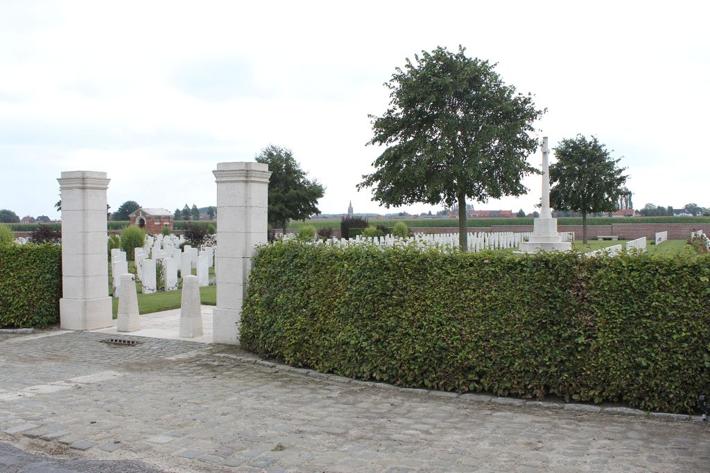
Historical Information: This cemetery takes its name from a line of huts strung along the road from Dickebusch (now Dikkebus) to Brandhoek, which were used by field ambulances during the 1917 Allied offensive on this front. Much of the cemetery was filled between July and November 1917 and nearly two thirds of the burials were of gunners from nearby artillery positions The cemetery was closed in April 1918 when the German advance brought the front line very close. The advance was finally halted on the eastern side of the village, following fierce fighting at Dickebusch Lake, on 8 May. There are now 1,094 Commonwealth burials of the First World War in the cemetery. The cemetery was designed by Sir Edwin Lutyens.
No. of Identified Casualties: 1094
Location Information: The Huts Cemetery is located 6 kilometres south west of Ieper town centre. From Ieper town centre the Dikkebusseweg (N375) is reached via Elverdingsestraat, straight over a roundabout onto J. Capronstraat (for 30 metres), then left along M. Fochlaan. Immediately after the train station the first right hand turning is the Dikkebusseweg. On reaching Dikkebus village the cemetery is reached by taking a right hand turning onto the Melkerijstraat. This road continues for 1 kilometre, over a crossroads and bending sharply to the right, then meeting a junction with the Steenakkerstraat. The cemetery is located 200 metres after this junction on the Steenakkerstraat.
Historical Information: This cemetery takes its name from a line of huts strung along the road from Dickebusch (now Dikkebus) to Brandhoek, which were used by field ambulances during the 1917 Allied offensive on this front. Much of the cemetery was filled between July and November 1917 and nearly two thirds of the burials were of gunners from nearby artillery positions The cemetery was closed in April 1918 when the German advance brought the front line very close. The advance was finally halted on the eastern side of the village, following fierce fighting at Dickebusch Lake, on 8 May. There are now 1,094 Commonwealth burials of the First World War in the cemetery. The cemetery was designed by Sir Edwin Lutyens.
No. of Identified Casualties: 1094
Nearby cemeteries
Dikkebus, Arrondissement Ieper, West Flanders, Belgium
- Total memorials4
- Percent photographed0%

Dikkebus, Arrondissement Ieper, West Flanders, Belgium
- Total memorials53
- Percent photographed100%
- Percent with GPS0%

Dikkebus, Arrondissement Ieper, West Flanders, Belgium
- Total memorials545
- Percent photographed95%
- Percent with GPS2%

Dikkebus, Arrondissement Ieper, West Flanders, Belgium
- Total memorials621
- Percent photographed96%
- Percent with GPS0%
- Added: 2 Dec 2005
- Find a Grave Cemetery ID: 2159858

Cemetery Photos
This is a carousel with slides. Use Next and Previous buttons to navigate, or jump to a slide with the slide dots. Use Escape keyboard button or the Close button to close the carousel.


Success
Uploading...
Waiting...
Failed
This photo was not uploaded because this cemetery already has 20 photos
This photo was not uploaded because you have already uploaded 5 photos to this cemetery
This photo was not uploaded because you have already uploaded 5 photos to this cemetery
Invalid File Type
Birth and death years unknown.
1 photo picked...
2 photos picked...
Uploading 1 Photo
Uploading 2 Photos
1 Photo Uploaded
2 Photos Uploaded
Size exceeded
Too many photos have been uploaded
"Unsupported file type"
• ##count## of 0 memorials with GPS displayed. Double click on map to view more.No cemeteries found