Moore Park Cemetery
Moore Park, Western Manitoba Census Division, Manitoba, Canada
About
-
Get directions Railway Avenue
Moore Park, RM of Minto-Odanah, Manitoba
R0K 1C0 CanadaCoordinates: 50.06702, -99.78638 - minnedosa.com/m/rural-municipality-of-minto-odanah/cemetery
- [email protected]
- +1-204-867-3282
-
Office Address
49 Main Street South
PO Box 1197,
Minnedosa, RM of Minto-Odanah, Manitoba
R0J 1E0 Canada - Cemetery ID:
-
Additional information
Located about 20 miles from Brandon, MB, on the northwest edge of Railway Avenue at the western edge of the town site of Moore Park, MB, the bend, about 0.5 miles (0.8 km) north of Provincial Range Road 72N
Any inquiries regarding this cemetery can be directed to the office of the RM of Minto-Odanah
Members have Contributed
Advertisement
Photos


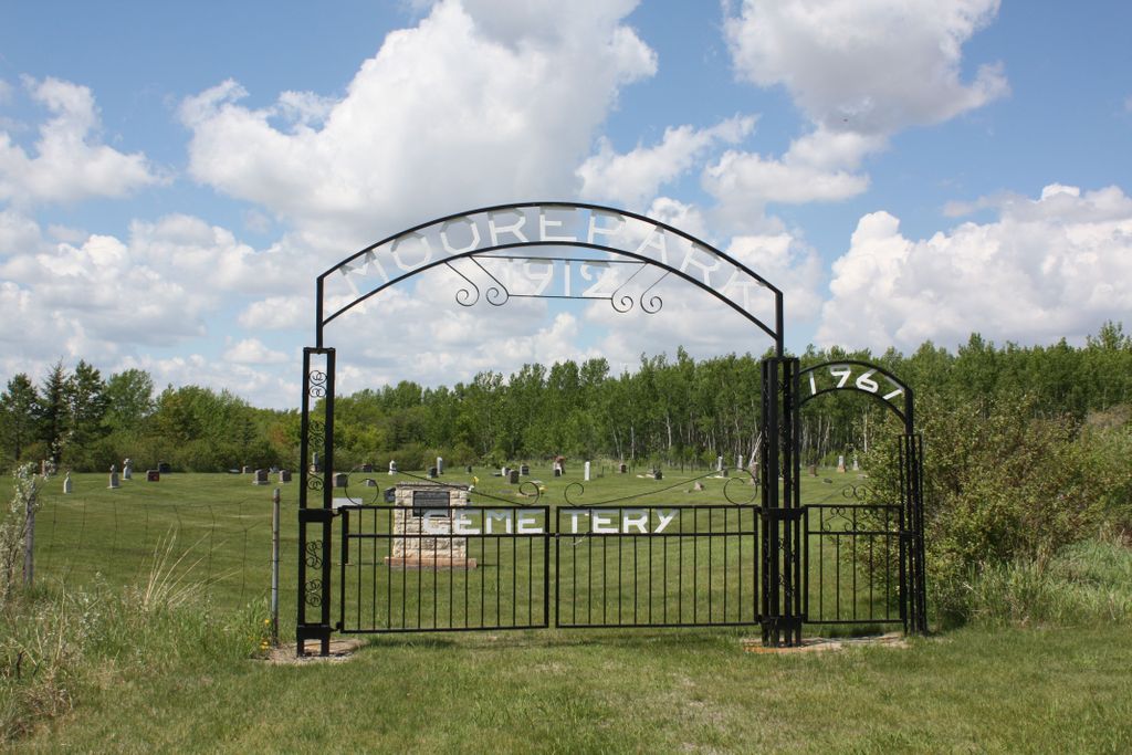
Owned and managed by the RM of Minto-Odanah and was established in 1912.
It is a well-kept prairie grass cemetery with a natural bluff on the north and east. It is page-wire enclosed with a nice double-arched metal gate at the southeast end inscribed "Moore Park Cemetery 1912" with 1957 above a small walk-in gate.
There is a roadway up the east side. Also, it is divided almost in half by another road.
Facing the gate stands a stone cairn dedicated in 1978 with a mailbox-type container on a stand beside the cairn for a guest book.
(Source: Manitoba Genealogical Society [Adapted] and the RM of Minto-Odanah's website)
A monument in the cemetery commemorates Moore Park United Church (aka St Paul's) which operated in the community from 1914 to 1972. The building has since been removed.
(Source: Manitoba Historical Society [Adapted])
Dominion Land Survey coordinates: LSD03-06-13-17-W1
In the Rural Municipality of RM of Minto-Odanah
A part of the town's story and those of its inhabitants from the early days of European settlement through roughly 1973 is told in the volumes "They called it Odanah", especially starting on page 23, and "A History of Elton Municipality - Homesteaders and Homemakers -- A History of Elton Municipality in its First Century".
Free digital versions of these and many other Manitoba local history books can be found online in the University of Manitoba Digital Collections. There is also a list of such books organized by district and town name on the Manitoba Historical Society's website on their page entitled "Finding Aid: Manitoba Local History Books".
A list of burials in this cemetery is available from the Manitoba Genealogical Society (reference #0089), transcribed by a member or members in 1979. Also available to MGS members is a searchable online database named the "MGS Manitoba Name Index" (or MANI). Some additional information is contained in the 1996 MGS publication "Carved in Stone: Manitoba Cemeteries and Burial Sites" (revised edition, Special Projects Publication, 106 pages).
Nearby cemeteries

Moore Park, Western Manitoba Census Division, Manitoba, Canada
- Total memorials52
- Percent photographed90%
- Percent with GPS0%

Moore Park, Western Manitoba Census Division, Manitoba, Canada
- Total memorials40
- Percent photographed95%
- Percent with GPS0%

Elton, Brandon Census Division, Manitoba, Canada
- Total memorials263
- Percent photographed94%
- Percent with GPS17%

Elton, Brandon Census Division, Manitoba, Canada
- Total memorials247
- Percent photographed92%
- Percent with GPS9%
- Added: 6 Sep 2014
- Find a Grave Cemetery ID: 2553003

Cemetery Photos
This is a carousel with slides. Use Next and Previous buttons to navigate, or jump to a slide with the slide dots. Use Escape keyboard button or the Close button to close the carousel.


Success
Uploading...
Waiting...
Failed
This photo was not uploaded because this cemetery already has 20 photos
This photo was not uploaded because you have already uploaded 5 photos to this cemetery
This photo was not uploaded because you have already uploaded 5 photos to this cemetery
Invalid File Type
Birth and death years unknown.
1 photo picked...
2 photos picked...
Uploading 1 Photo
Uploading 2 Photos
1 Photo Uploaded
2 Photos Uploaded
Size exceeded
Too many photos have been uploaded
"Unsupported file type"
• ##count## of 0 memorials with GPS displayed. Double click on map to view more.No cemeteries found