St Clements Church Yard
Also known as Saint Clements Anglican Church Cemetery , Mapleton Saint Clements Anglican Cemetery , Saint Clements Cemetery , Saint Clements Mapleton Columbarium
Old England, Selkirk Census Division, Manitoba, Canada
About
-
Get directions 7 St Clement Drive
St Clements, RM of St Andrews, Manitoba
R1A 4A1 CanadaCoordinates: 50.12573, -96.89686 - stclementchurch.ca/our-history
- [email protected]
- +1-204-482-7237
-
Office Address
1178 River Road
St Clements, RM of St Andrews, Manitoba
R1A 4A1 Canada - Cemetery ID:
-
Additional information
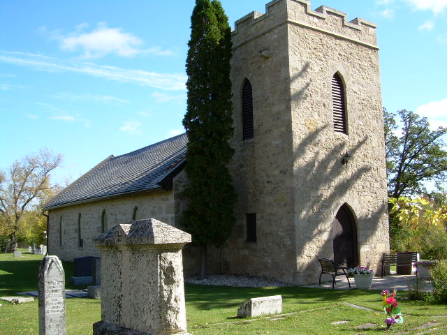
The most northerly of the cemeteries along this stretch of road, the Church Yard is readily visible on the east side of Main Street (aka Provincial Highway 9); access to it is via the entrance on St Clements Drive, roughly halfway between Main Street and River Road.
When approaching from River Road, the church building is the most prominent feature.
There is only one central roadway requiring pedestrian travel across the lawns and between the rows for access to most of the graves.
Members have Contributed
Advertisement
Photos


The actual name is St. Clements Church Yard, and it is inter-denominational. It is not an Anglican churchyard. St Clements is its keeper.
For years St. Clements congregation included the rich, the powerful, and the humble. For many years it was the official chapel of the Lower Fort Garry. It is stated that gallant gentlemen, adventurers of the honourable Hudson's Bay Company, clad in broadcloth, and their ladies in silks and satin, made their way to this little house of God, and sat in seats reserved for their occupation. For some time, St. Clements was also the garrison church of the lower Red River, and scarlet tunics added colour to the scene of the Sabbath splendor. These gallant people sat beside the humble people of the area.
But times changed and the Lower Fort ceased to hold its important position in the trading of the Hudson Bay Company. The Troops moved on to other quarters. No longer did the fashionable ladies and gentlemen of the mid-Victorian era fill the pews. But there remained, and remains today a congregation of ordinary men and women who are keen about their responsibility as stewards of St. Clements.
The approximately 7 acres of land holds over 10,000 graves. The graves are all marked and the names have been kept on a database. Anyone looking for their loved ones' graves is encouraged to contact us, as it is most likely that we can direct them to the grave(s) of their loved one(s).
The first grave was a child (Charles Herbert Kirkby (16 months old)) buried before the church was built. The land was consecrated and the child's remains were laid to rest. There are now 4 areas for babies.
The oldest headstone that we can read (for Ellen Begg) is dated 1867 and is located just outside the church doors. Samuel Taylor, who built the church, is buried in the family plot behind the church.
There are over 400 headstones for those who died at war.
There is a section of the graveyard that has been requested specifically for the Baha'i Faith.
A columbarium is a relatively recent addition to the property.
There is a section of the graveyard used for the City of Selkirk - Province of Manitoba for those who cannot afford their funeral and do not have another place to be laid to rest.
(Source: Saint Clements Anglican Church website [2023/09; Adapted])
Established in 1860, (Mapleton) St Clement's Anglican Cemetery is one of the oldest cemeteries in the province. The property covers a large area, right down to the drive along the river. The oldest part of the cemetery surrounds a small picturesque and well-kept church and there are burials here for some of the patients of the former "Selkirk Mental Hospital".
In the oldest parts of the cemetery, it is almost impossible to delineate rows. Many of the flat slab markers are partially covered and could be difficult to locate.
(Source: Manitoba Genealogical Society [Adapted])
Construction of the St. Clements Anglican Church, in what later became the Rural Municipality of St. Andrews, started in 1860 under the supervision of stonemason Samuel Taylor, and the first service was held in it in December 1861. The bell tower was added in 1928. The building is a sturdy stone structure in the English Parish Gothic Revival style with a crenellated bell tower and pointed arch windows and door. Inside are stained glass windows designed by artist Leo Mol.
It is surrounded by a large cemetery that contains the graves of many of the founding families of Selkirk.
(Source: Manitoba Historical Society [Adapted])
Dominion Land Survey coordinates: LSD07-30-13-05-E1
In the Rural Municipality of St Andrews
Along with many volumes dedicated to the early days of the City of Selkirk and the Selkirk Settlers, part of the area's story and those of its many inhabitants from the early days of European settlement through roughly 2000 is told in the volume "Beyond the Gates of Lower Fort Garry 1880-1981" and its sequel "Beyond the Gates of Lower Fort Garry - A Sequel".
Free digital versions of these and many other Manitoba local history books can be found online in the University of Manitoba Digital Collections. There is also a list of such books organized by district and town name on the Manitoba Historical Society's website on their page entitled "Finding Aid: Manitoba Local History Books".
A list of burials in this cemetery is available from the Manitoba Genealogical Society (reference #0504), transcribed by a member or members in 1990 and updated in 2019. Also available to MGS members is a searchable online database named the "MGS Manitoba Name Index" (or MANI). Some additional information is contained in the 1996 MGS publication "Carved in Stone: Manitoba Cemeteries and Burial Sites" (revised edition, Special Projects Publication, 106 pages).
Additionally, many records for Anglican congregations in Manitoba and over part of the territory designated historically as "Rupert's Land" (esp, as bounded on the south by the U.S. border, extending north into the Manitoba Interlake Region past Fairford, with the western boundary reaching into the Pembina Hills and includes Portage la Prairie, eastward the diocese stretches to Sioux Lookout/Atikokan) are now with the Diocese of Rupert's Land and are kept in their offices in Winnipeg, Manitoba, Canada.
Nearby cemeteries

Old England, Selkirk Census Division, Manitoba, Canada
- Total memorials749
- Percent photographed96%
- Percent with GPS1%

Old England, Selkirk Census Division, Manitoba, Canada
- Total memorials1k+
- Percent photographed97%
- Percent with GPS0%

East Selkirk, Selkirk Census Division, Manitoba, Canada
- Total memorials37
- Percent photographed97%
- Percent with GPS0%

Selkirk, Selkirk Census Division, Manitoba, Canada
- Total memorials136
- Percent photographed96%
- Percent with GPS5%
- Added: 17 Jan 2008
- Find a Grave Cemetery ID: 2246138

Cemetery Photos
This is a carousel with slides. Use Next and Previous buttons to navigate, or jump to a slide with the slide dots. Use Escape keyboard button or the Close button to close the carousel.


Success
Uploading...
Waiting...
Failed
This photo was not uploaded because this cemetery already has 20 photos
This photo was not uploaded because you have already uploaded 5 photos to this cemetery
This photo was not uploaded because you have already uploaded 5 photos to this cemetery
Invalid File Type
Birth and death years unknown.
1 photo picked...
2 photos picked...
Uploading 1 Photo
Uploading 2 Photos
1 Photo Uploaded
2 Photos Uploaded
Size exceeded
Too many photos have been uploaded
"Unsupported file type"
• ##count## of 0 memorials with GPS displayed. Double click on map to view more.No cemeteries found