Vlamertinghe Military Cemetery
Vlamertinghe, Arrondissement Ieper, West Flanders, Belgium
About
-
- Cemetery ID:
Members have Contributed
Advertisement
Photos


Location Information: Vlamertinge Military Cemetery is located 5 Km west of Ieper town centre, on the Hospitaalstraat, which is a road leading from the Poperingseweg. (Connecting Ieper to Poperinge). (* Vlamertinge is the modern spelling of Vlamertinghe). From Ieper town centre the Poperingseweg (N308), is reached via Elverdingsestraat then straight over two small roundabouts in the J. Capronstraat. The Poperingseweg is a continuation of J. Capronstraat and begins after a prominent railway level crossing. On reaching the village of Vlamertinge the cemetery is located on the Hospitaalstraat, which is the second right turning after the village church. The cemetery lies 50 metres along the Hospitaalstraat on the right hand side of the road.
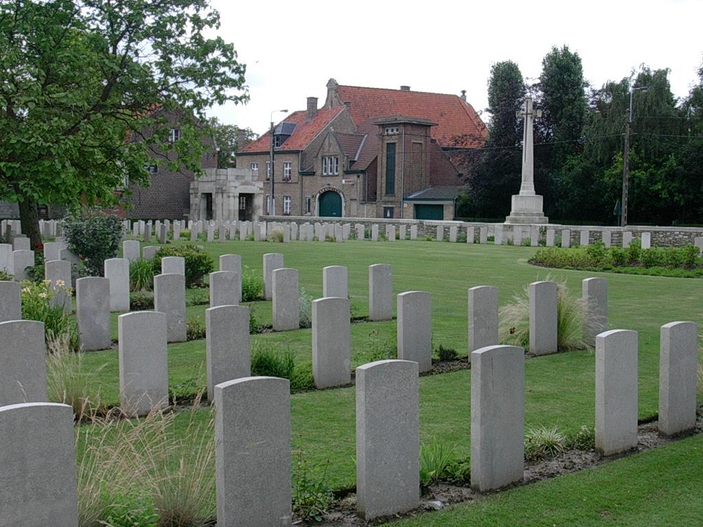
Historical Information: Vlamertinghe Military Cemetery was started by French troops in 1914 and was taken over by Commonwealth forces in April 1915. It was used by fighting units and field ambulances until June 1917, when the land adjoining the cemetery was claimed for a military railway preventing further extension. The cemetery is remarkable for the care with which men of the same unit were buried side by side if they died at about the same time. There is also a very high proportion of graves of Territorial units, in particular Lancashire Territorials, who have nearly 250 graves in plots IV, V and VI. During the early months of 1917, whenever it was possible, the 55th Division brought their dead from the front for burial here. The cemetery now contains 1,175 Commonwealth burials of the First World War. The French graves were removed after the war, but three German war graves remain. There are also four Second World War burials dating from the Allied retreat to Dunkirk in May 1940. The cemetery was designed by Sir Reginald Blomfield.
No. of Identified Casualties: 1164
This figure includes Foreign and Non-World
Location Information: Vlamertinge Military Cemetery is located 5 Km west of Ieper town centre, on the Hospitaalstraat, which is a road leading from the Poperingseweg. (Connecting Ieper to Poperinge). (* Vlamertinge is the modern spelling of Vlamertinghe). From Ieper town centre the Poperingseweg (N308), is reached via Elverdingsestraat then straight over two small roundabouts in the J. Capronstraat. The Poperingseweg is a continuation of J. Capronstraat and begins after a prominent railway level crossing. On reaching the village of Vlamertinge the cemetery is located on the Hospitaalstraat, which is the second right turning after the village church. The cemetery lies 50 metres along the Hospitaalstraat on the right hand side of the road.
Historical Information: Vlamertinghe Military Cemetery was started by French troops in 1914 and was taken over by Commonwealth forces in April 1915. It was used by fighting units and field ambulances until June 1917, when the land adjoining the cemetery was claimed for a military railway preventing further extension. The cemetery is remarkable for the care with which men of the same unit were buried side by side if they died at about the same time. There is also a very high proportion of graves of Territorial units, in particular Lancashire Territorials, who have nearly 250 graves in plots IV, V and VI. During the early months of 1917, whenever it was possible, the 55th Division brought their dead from the front for burial here. The cemetery now contains 1,175 Commonwealth burials of the First World War. The French graves were removed after the war, but three German war graves remain. There are also four Second World War burials dating from the Allied retreat to Dunkirk in May 1940. The cemetery was designed by Sir Reginald Blomfield.
No. of Identified Casualties: 1164
This figure includes Foreign and Non-World
Nearby cemeteries
Vlamertinghe, Arrondissement Ieper, West Flanders, Belgium
- Total memorials15
- Percent photographed27%

Vlamertinghe, Arrondissement Ieper, West Flanders, Belgium
- Total memorials251
- Percent photographed100%
- Percent with GPS0%

Vlamertinghe, Arrondissement Ieper, West Flanders, Belgium
- Total memorials1k+
- Percent photographed89%
- Percent with GPS0%

Vlamertinghe, Arrondissement Ieper, West Flanders, Belgium
- Total memorials674
- Percent photographed92%
- Percent with GPS1%
- Added: 5 Sep 2004
- Find a Grave Cemetery ID: 1992245

Cemetery Photos
This is a carousel with slides. Use Next and Previous buttons to navigate, or jump to a slide with the slide dots. Use Escape keyboard button or the Close button to close the carousel.


Success
Uploading...
Waiting...
Failed
This photo was not uploaded because this cemetery already has 20 photos
This photo was not uploaded because you have already uploaded 5 photos to this cemetery
This photo was not uploaded because you have already uploaded 5 photos to this cemetery
Invalid File Type
Birth and death years unknown.
1 photo picked...
2 photos picked...
Uploading 1 Photo
Uploading 2 Photos
1 Photo Uploaded
2 Photos Uploaded
Size exceeded
Too many photos have been uploaded
"Unsupported file type"
• ##count## of 0 memorials with GPS displayed. Double click on map to view more.No cemeteries found