Hallvardskatedralens ruin
Also known as St Hallvard Cathedral
Oslo, Oslo kommune, Oslo fylke, Norway
About
-
Get directions Minneparken
Oslo, Oslo kommune, Oslo fylke 0192 NorwayCoordinates: 59.90588, 10.76867 - Cemetery ID:
Members have Contributed
Advertisement
Photos
No additional photos.
Add PhotosThe cathedral was probably completed by the spring of 1130 when Sigurd I Magnusson (Sigurd Jorsalfare) died and was buried as the first king in the church. His son, King Magnus IV Sigurdsson den blinde (the blind) was buried beside his father in 1139. Håkon Håkonsson Unge (Young), king's son, died in 1257; he was the last royal to be buried in Hallvardskatedralen. After this, it was Mariakirken (the Church of Mary) who took over as a royal burial chapel. But bishops and other prominent people were still buried here.
Hallvardskatedralen was hit by fire three times: In 1137 - the church was soon restored. The next fire was in 1567, but the church was rebuilt. The last time was the big city fire in 1624, but Hallvardskatedralen was in relatively good condition after the fire. But most of old Oslo burned down, and King Christian IV ordered the city to be moved to the other side of Bjørvika - under the protection of the Akershus fortress and given the name Christiania. Hallvardskatedralen was repaired and maintained as the Cathedral of Eastern Norway Øst-Norge) until 1639. Then Hellig Trefoldigheds kirke (the Holy Trinity Church) at Christiania took over as the main church of the diocese.
The old cathedral at Oslo Square (torg) was now downgraded to the parish church for Aker parish. The magnificent church building in Old Town (Gamlebyen) was left with little honor and decay. The last known service in Hallvardskatedralen was held in 1654. The decay accelerated and in 1696 the old cathedral was demolished. Stone was used for construction work on the Akershus fortress and as a street foundation in Grønland. The last remains of the building were demolished around 1780.
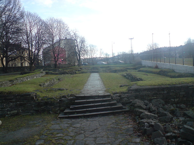
Other buildings were later build in the area of Hallvardskatedralen. In the mid-1800s, work was started on constructing railways in this area, and the ruins were uncovered through construction work and archaeological investigations. In the 1860s and 70s, the last private buildings on the church site were demolished. Around 1880, Bispegata was extended east across the property. Excavations of Hallvardskatedralen were begun in 1865, and work continued in 1879. The archaeological excavations continued in the 1920s - and in 1921 the entire ruins of Hallvardskatedralen were visible. It was the main attraction when Minneparken (the Memorial Park) opened in 1932.
Minneparken was curtailed in connection with the expansion of Bispegata's eastern extension towards the end of the 1930s. The park was even more curtailed when the need to build wider roads in the 1960s came along. It was then decided to put the south section under the concrete lid. The Bispegata motorway with a 4-lane road was laid over the covered area. In the 2000s, the roadway in Bispegata was narrowed, and more of the ruin could thus be visible again.
Today, the memorial park (13.7 dekar) is 3.38 acres (US / UK) and borders St. Halvards plass (square) and Oslo gate in the west with Oslo Ladegård on the other side of the street, Bispegata in the south, St. Halvards gate in the southeast, Egedes gate in the east and Arups gate in the north. It is located one kilometer (0,622 mile US/UK) east of Oslo Central Station, on a slight east slope (svak østhelling).
The cathedral was probably completed by the spring of 1130 when Sigurd I Magnusson (Sigurd Jorsalfare) died and was buried as the first king in the church. His son, King Magnus IV Sigurdsson den blinde (the blind) was buried beside his father in 1139. Håkon Håkonsson Unge (Young), king's son, died in 1257; he was the last royal to be buried in Hallvardskatedralen. After this, it was Mariakirken (the Church of Mary) who took over as a royal burial chapel. But bishops and other prominent people were still buried here.
Hallvardskatedralen was hit by fire three times: In 1137 - the church was soon restored. The next fire was in 1567, but the church was rebuilt. The last time was the big city fire in 1624, but Hallvardskatedralen was in relatively good condition after the fire. But most of old Oslo burned down, and King Christian IV ordered the city to be moved to the other side of Bjørvika - under the protection of the Akershus fortress and given the name Christiania. Hallvardskatedralen was repaired and maintained as the Cathedral of Eastern Norway Øst-Norge) until 1639. Then Hellig Trefoldigheds kirke (the Holy Trinity Church) at Christiania took over as the main church of the diocese.
The old cathedral at Oslo Square (torg) was now downgraded to the parish church for Aker parish. The magnificent church building in Old Town (Gamlebyen) was left with little honor and decay. The last known service in Hallvardskatedralen was held in 1654. The decay accelerated and in 1696 the old cathedral was demolished. Stone was used for construction work on the Akershus fortress and as a street foundation in Grønland. The last remains of the building were demolished around 1780.
Other buildings were later build in the area of Hallvardskatedralen. In the mid-1800s, work was started on constructing railways in this area, and the ruins were uncovered through construction work and archaeological investigations. In the 1860s and 70s, the last private buildings on the church site were demolished. Around 1880, Bispegata was extended east across the property. Excavations of Hallvardskatedralen were begun in 1865, and work continued in 1879. The archaeological excavations continued in the 1920s - and in 1921 the entire ruins of Hallvardskatedralen were visible. It was the main attraction when Minneparken (the Memorial Park) opened in 1932.
Minneparken was curtailed in connection with the expansion of Bispegata's eastern extension towards the end of the 1930s. The park was even more curtailed when the need to build wider roads in the 1960s came along. It was then decided to put the south section under the concrete lid. The Bispegata motorway with a 4-lane road was laid over the covered area. In the 2000s, the roadway in Bispegata was narrowed, and more of the ruin could thus be visible again.
Today, the memorial park (13.7 dekar) is 3.38 acres (US / UK) and borders St. Halvards plass (square) and Oslo gate in the west with Oslo Ladegård on the other side of the street, Bispegata in the south, St. Halvards gate in the southeast, Egedes gate in the east and Arups gate in the north. It is located one kilometer (0,622 mile US/UK) east of Oslo Central Station, on a slight east slope (svak østhelling).
Nearby cemeteries

Oslo, Oslo kommune, Oslo fylke, Norway
- Total memorials151
- Percent photographed84%
- Percent with GPS30%

Oslo, Oslo kommune, Oslo fylke, Norway
- Total memorials3
- Percent photographed33%
- Percent with GPS0%
Oslo, Oslo kommune, Oslo fylke, Norway
- Total memorials0
- Percent photographed0%
- Percent with GPS0%

Oslo, Oslo kommune, Oslo fylke, Norway
- Total memorials28
- Percent photographed75%
- Percent with GPS14%
- Added: 22 Dec 2011
- Find a Grave Cemetery ID: 2430666

Cemetery Photos
This is a carousel with slides. Use Next and Previous buttons to navigate, or jump to a slide with the slide dots. Use Escape keyboard button or the Close button to close the carousel.
Success
Uploading...
Waiting...
Failed
This photo was not uploaded because this cemetery already has 20 photos
This photo was not uploaded because you have already uploaded 5 photos to this cemetery
This photo was not uploaded because you have already uploaded 5 photos to this cemetery
Invalid File Type
Birth and death years unknown.
1 photo picked...
2 photos picked...
Uploading 1 Photo
Uploading 2 Photos
1 Photo Uploaded
2 Photos Uploaded
Size exceeded
Too many photos have been uploaded
"Unsupported file type"
• ##count## of 0 memorials with GPS displayed. Double click on map to view more.No cemeteries found