Mount Adnah Cemetery
Fulton, Oswego County, New York, USA
About
-
Get directions 706 East Broadway (Co. Route 3)
Fulton, New York 13069 United StatesCoordinates: 43.32080, -76.40190 - (315) 592- 7338
- Cemetery ID:
Members have Contributed
Advertisement
Photos


Click here for the cemetery map.
The word Adnah is Syrian meaning "rest" or "repose." The cemetery therefore became the "Mount of Repose". People of all faiths and beliefs are welcome to be buried in Mt. Adnah Cemetery
It was founded on June 2, 1851. It is a perfect example of a nineteenth century-designed landscape called a "rural cemetery". The establishment of Mt. Adnah was a direct response to the problem of a rapidly growing community with no truly permanent resting place for its dead. Nineteenth century histories note a sequence of burial sites near the Village of Fulton, with removals made from one site to the next, as property was needed for housing. The last such removal was made in 1875 with the remains of the old cemetery at Rochester and Seventh Street re-interred in Mt. Adnah. At the 1851 meeting of Mt. Adnah's founders, the following men were appointed trustees: Aaron G. Fish, Henry Broadwell, Orsman Ottway Shumway, Sands Niles Kenyon, Dr. John E. Dutton, Willard Osgood, Dr. Moses L. Lee, William Schenck and Lewis E. Loomis. Peter Schenck, a highly regarded surveyor, with the assistance of Dr. Moses L. Lee, was employed in 1853 to survey, layout and map 12 acres on the northwest side of the property. The pair soon added another eight acres to their cemetery layout. While its design was relatively simple compared to big city cemeteries, Mt. Adnah incorporated all the necessary design principles for a rural cemetery. An 1867 map of Fulton included the cemetery plan and showed very clearly that Peter Schenck laid out the cemetery with a curvilinear circulation system that took advantage of the site's naturally varied terrain. Records indicate that on September 23, 1853, D. R. Case was the first internment in Mt. Adnah Cemetery. As Fulton grew during the late 19th century, additional land was purchased, bringing the total to 44 acres.
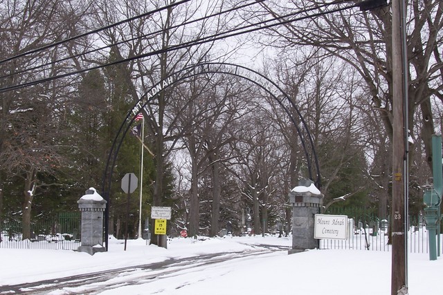
As early as 1854, a fence was deemed necessary "to protect the cemetery" from cattle wandering onto the property from nearby farms. Proper fencing was a constant concern as was the need for a formal gateway, first discussed in 1866. A succession of fences and gates culminated in the ornamental stone and cast iron entrance archway erected in 1894 and cast iron fencing built in 1899 and 1900. Other early improvements made in the 19th century included the superintendent's home built in 1872, and an adjacent barn and receiving vault constructed in 1877.
The most significant structure in the cemetery was the Case Memorial Chapel built in 1909. It was donated by Eva Dale Case Lee, wife of Dr Charles Rowe Lee, in honor of her late parents, Mr. and Mrs. George M. Case. The chapel had to be torn down in 1999. Mr. Case was a Fulton native, who made a fortune contracting work on the canals and elsewhere, served in the State Assembly and eventually became president of the Citizen's National Bank of Fulton. He was also a trustee of the Mt. Adnah Cemetery Association from 1871 to 1897. The cemetery was listed on the State and National Registers of Historic Sites in 2001.
Points of interest would be the family mausoleums (Sect. 14+15), like that of the Pratt Family and the new Cremation Garden in Section 29. Parts of Section 10 is what some would call the "Potter's Field", with many unmarked graves of people with no families, therefore without grave markers. Also in Section 10, an area along the fence, with burials of infants and babies (known as "Babyland"), many without markers as well.
To the south-east of Mount Adnah is the Catholic Saint Marys Cemetery.
Click here for the cemetery map.
The word Adnah is Syrian meaning "rest" or "repose." The cemetery therefore became the "Mount of Repose". People of all faiths and beliefs are welcome to be buried in Mt. Adnah Cemetery
It was founded on June 2, 1851. It is a perfect example of a nineteenth century-designed landscape called a "rural cemetery". The establishment of Mt. Adnah was a direct response to the problem of a rapidly growing community with no truly permanent resting place for its dead. Nineteenth century histories note a sequence of burial sites near the Village of Fulton, with removals made from one site to the next, as property was needed for housing. The last such removal was made in 1875 with the remains of the old cemetery at Rochester and Seventh Street re-interred in Mt. Adnah. At the 1851 meeting of Mt. Adnah's founders, the following men were appointed trustees: Aaron G. Fish, Henry Broadwell, Orsman Ottway Shumway, Sands Niles Kenyon, Dr. John E. Dutton, Willard Osgood, Dr. Moses L. Lee, William Schenck and Lewis E. Loomis. Peter Schenck, a highly regarded surveyor, with the assistance of Dr. Moses L. Lee, was employed in 1853 to survey, layout and map 12 acres on the northwest side of the property. The pair soon added another eight acres to their cemetery layout. While its design was relatively simple compared to big city cemeteries, Mt. Adnah incorporated all the necessary design principles for a rural cemetery. An 1867 map of Fulton included the cemetery plan and showed very clearly that Peter Schenck laid out the cemetery with a curvilinear circulation system that took advantage of the site's naturally varied terrain. Records indicate that on September 23, 1853, D. R. Case was the first internment in Mt. Adnah Cemetery. As Fulton grew during the late 19th century, additional land was purchased, bringing the total to 44 acres.
As early as 1854, a fence was deemed necessary "to protect the cemetery" from cattle wandering onto the property from nearby farms. Proper fencing was a constant concern as was the need for a formal gateway, first discussed in 1866. A succession of fences and gates culminated in the ornamental stone and cast iron entrance archway erected in 1894 and cast iron fencing built in 1899 and 1900. Other early improvements made in the 19th century included the superintendent's home built in 1872, and an adjacent barn and receiving vault constructed in 1877.
The most significant structure in the cemetery was the Case Memorial Chapel built in 1909. It was donated by Eva Dale Case Lee, wife of Dr Charles Rowe Lee, in honor of her late parents, Mr. and Mrs. George M. Case. The chapel had to be torn down in 1999. Mr. Case was a Fulton native, who made a fortune contracting work on the canals and elsewhere, served in the State Assembly and eventually became president of the Citizen's National Bank of Fulton. He was also a trustee of the Mt. Adnah Cemetery Association from 1871 to 1897. The cemetery was listed on the State and National Registers of Historic Sites in 2001.
Points of interest would be the family mausoleums (Sect. 14+15), like that of the Pratt Family and the new Cremation Garden in Section 29. Parts of Section 10 is what some would call the "Potter's Field", with many unmarked graves of people with no families, therefore without grave markers. Also in Section 10, an area along the fence, with burials of infants and babies (known as "Babyland"), many without markers as well.
To the south-east of Mount Adnah is the Catholic Saint Marys Cemetery.
Nearby cemeteries

Fulton, Oswego County, New York, USA
- Total memorials8k+
- Percent photographed92%
- Percent with GPS1%

Fulton, Oswego County, New York, USA
- Total memorials18
- Percent photographed22%
- Percent with GPS17%
Fulton, Oswego County, New York, USA
- Total memorials23
- Percent photographed0%

- Added: 1 Jan 2000
- Find a Grave Cemetery ID: 65316

Cemetery Photos
This is a carousel with slides. Use Next and Previous buttons to navigate, or jump to a slide with the slide dots. Use Escape keyboard button or the Close button to close the carousel.


Success
Uploading...
Waiting...
Failed
This photo was not uploaded because this cemetery already has 20 photos
This photo was not uploaded because you have already uploaded 5 photos to this cemetery
This photo was not uploaded because you have already uploaded 5 photos to this cemetery
Invalid File Type
Birth and death years unknown.
1 photo picked...
2 photos picked...
Uploading 1 Photo
Uploading 2 Photos
1 Photo Uploaded
2 Photos Uploaded
Size exceeded
Too many photos have been uploaded
"Unsupported file type"
• ##count## of 0 memorials with GPS displayed. Double click on map to view more.No cemeteries found