Hamiota Cemetery
Hamiota, Western Manitoba Census Division, Manitoba, Canada
About
-
Get directions 79200 Provincial Highway 21
Hamiota, RM of Hamiota, Manitoba
R0M 0T0 CanadaCoordinates: 50.16974, -100.59886 - hamiota.com/maps/
- [email protected]
- +1-204-764-3050
-
Office Address
RM of Hamiota
75 Maple Avenue
Box 100
Hamiota, RM of Hamiota, Manitoba
R0M 0T0 Canada - Cemetery ID:
-
Additional information
Located about 0.5 miles (0.8 km) south of the town of Hamiota, MB, on the west side of Provincial Highway 21
A minimal network of roadways provides vehicular access to the grounds.
Burial records can be consulted by reaching out to the RM staff.
NOTE: The RM provides an interactive map of the cemetery providing lot and plot numbers, along with details of the person interred at each location
Members have Contributed
Advertisement
Photos
No additional photos.
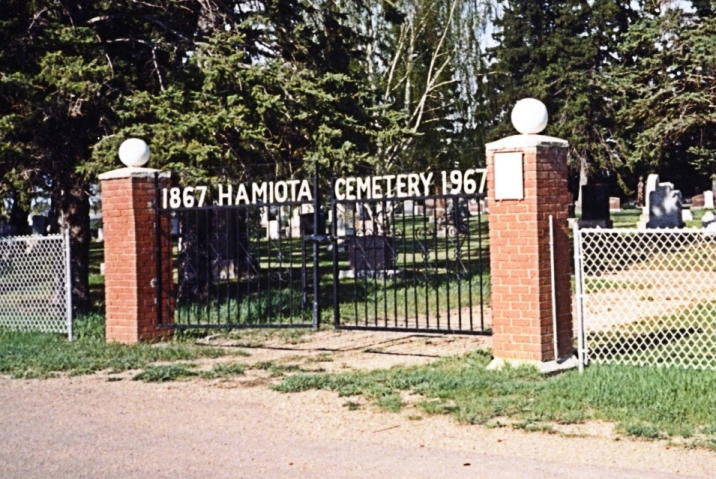
Add PhotosThe Hamiota Cemetery, laid out shortly after the townsite was chosen, comes in for its share of beauty. The carefully and artistically laid out flower plots; the well-trimmed and cared-for trees and the shorn grass help to make this hallowed spot a compliment to the village. The Memorial ground, on which stands a cenotaph erected in memory of those who fell in the First War, is also a beauty spot during the summer months.
(Source: The History of Hamiota, p 35 [circa 1970; Adapted])
Dominion Land Survey coordinates: LSD04-08-14-23-W1
In the Rural Municipality of Hamiota
As noted above, a part of the town's story and those of its inhabitants from the early days of European settlement through roughly 1970 is told in the volume "The History of Hamiota", especially starting on page 35. A free digital version of this and many other Manitoba local history books can be found online in the University of Manitoba Digital Collections. There is also a list of such books organized by district and town name on the Manitoba Historical Society's website on their page entitled "Finding Aid: Manitoba Local History Books".
A list of burials in this cemetery is available from the Manitoba Genealogical Society (reference #1226), transcribed by a member or members in 1998.
The Hamiota Cemetery, laid out shortly after the townsite was chosen, comes in for its share of beauty. The carefully and artistically laid out flower plots; the well-trimmed and cared-for trees and the shorn grass help to make this hallowed spot a compliment to the village. The Memorial ground, on which stands a cenotaph erected in memory of those who fell in the First War, is also a beauty spot during the summer months.
(Source: The History of Hamiota, p 35 [circa 1970; Adapted])
Dominion Land Survey coordinates: LSD04-08-14-23-W1
In the Rural Municipality of Hamiota
As noted above, a part of the town's story and those of its inhabitants from the early days of European settlement through roughly 1970 is told in the volume "The History of Hamiota", especially starting on page 35. A free digital version of this and many other Manitoba local history books can be found online in the University of Manitoba Digital Collections. There is also a list of such books organized by district and town name on the Manitoba Historical Society's website on their page entitled "Finding Aid: Manitoba Local History Books".
A list of burials in this cemetery is available from the Manitoba Genealogical Society (reference #1226), transcribed by a member or members in 1998.
Nearby cemeteries

Hamiota, Western Manitoba Census Division, Manitoba, Canada
- Total memorials5
- Percent photographed100%
- Percent with GPS0%

Oakner, Western Manitoba Census Division, Manitoba, Canada
- Total memorials292
- Percent photographed98%
- Percent with GPS47%

Crandall, Western Manitoba Census Division, Manitoba, Canada
- Total memorials570
- Percent photographed90%
- Percent with GPS2%

Oak River, Western Manitoba Census Division, Manitoba, Canada
- Total memorials643
- Percent photographed97%
- Percent with GPS87%
- Added: 9 Oct 2007
- Find a Grave Cemetery ID: 2235008

Cemetery Photos
This is a carousel with slides. Use Next and Previous buttons to navigate, or jump to a slide with the slide dots. Use Escape keyboard button or the Close button to close the carousel.
Success
Uploading...
Waiting...
Failed
This photo was not uploaded because this cemetery already has 20 photos
This photo was not uploaded because you have already uploaded 5 photos to this cemetery
This photo was not uploaded because you have already uploaded 5 photos to this cemetery
Invalid File Type
Birth and death years unknown.
1 photo picked...
2 photos picked...
Uploading 1 Photo
Uploading 2 Photos
1 Photo Uploaded
2 Photos Uploaded
Size exceeded
Too many photos have been uploaded
"Unsupported file type"
• ##count## of 0 memorials with GPS displayed. Double click on map to view more.No cemeteries found