Crandall Cemetery
Crandall, Western Manitoba Census Division, Manitoba, Canada
About
-
Get directions 78400 Provincial Road 254
(aka Provincial Road 145W)
Crandall, Prairie View, Manitoba
R0M 0H0 CanadaCoordinates: 50.15696, -100.78223 - myprairieview.ca/p/cemeteries
- [email protected]
- +1-204-842-3403
-
Office Address
Municipality of Prairie View
678 Main Street
PO Box 70
Birtle, Prairie View, Manitoba
R0M 0C0 Canada - Cemetery ID:
-
Additional information
Located about 0.5 miles (0.8 km) due north of the community of Crandall, MB, on the east side of Provincial Road 254 (aka Provincial Road 145W), between Provincial Range Roads 78N and 79N
A single minimally maintained track provides nominal vehicular access to the grounds.
The cemetery is managed by a local committee, whose current contact information is available on the Municipality of Prairie View's website [2024/03].
Members have Contributed
Advertisement
Photos
No additional photos.
Add PhotosThe land for the Crandall Cemetery was donated by Mr. Edward Vance. A survey was made and dated December 4, 1902. The Cemetery is located a quarter mile north of town. The first grave, James Kyle, died May 16, 1901, age 71 years. They lived on NE 25-13-25[-W1].
Our cemetery is a very lovely place for our loved ones, with trees all around and many beautiful flowers in summer. Cemetery caretakers were Ed Vance, J. Young, J. Hyndman, A. Groves, S. Robus, Everet Mason and Bob Hirst. Mrs. E. Robus has been caretaker of records for 24 years [1971].
(Source: The Chronicles of Crandall (1971) - A History of Crandall and Surrounding Districts, p 71 [1971; Adapted])
NOTE: The related and later local history book "Crandall History Book (2000)" contains a list of burials known to the authors at the time of publication
~~~~~~~~~~
Established in 1902, the land for the Crandall Cemetery was donated by Mr. Edward Vance. It was surveyed in 1902.
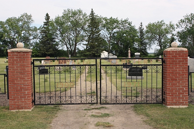
The cemetery is approximately 360 feet by 330 feet (~110m x 100m) with plots 16 x 32 feet (~4.9m x 9.8m). Pine trees surround it. An iron gate with square brick posts with concrete rugby balls on top lead into it from the west.
(Source: Manitoba Genealogical Society [Adapted])
~~~~~~~~~~
Dominion Land Survey coordinates: LSD05-01-14-25-W1
In the Municipality of Prairie View
~~~~~~~~~~
As noted above, a part of the community's story, and those of its inhabitants, from the early days of European settlement through roughly 2000 is told in the volume "The Chronicles of Crandall (1971) - A History of Crandall and Surrounding Districts", especially on the cited page, and in the later related work entitled "Crandall History Book (2000)".
Free digital versions of these and many other Manitoba local history books can be found online in the University of Manitoba Digital Collections. There is also a list of such books organized by district and town name on the Manitoba Historical Society's website on their page entitled "Finding Aid: Manitoba Local History Books".
A list of burials in this cemetery is available from the Manitoba Genealogical Society (reference #0030), transcribed by a member or members in 1979. Also available to MGS members is a searchable online database named the "MGS Manitoba Name Index" (or MANI). Some additional information is contained in the 1996 MGS publication "Carved in Stone: Manitoba Cemeteries and Burial Sites" (revised edition, Special Projects Publication, 106 pages).
The land for the Crandall Cemetery was donated by Mr. Edward Vance. A survey was made and dated December 4, 1902. The Cemetery is located a quarter mile north of town. The first grave, James Kyle, died May 16, 1901, age 71 years. They lived on NE 25-13-25[-W1].
Our cemetery is a very lovely place for our loved ones, with trees all around and many beautiful flowers in summer. Cemetery caretakers were Ed Vance, J. Young, J. Hyndman, A. Groves, S. Robus, Everet Mason and Bob Hirst. Mrs. E. Robus has been caretaker of records for 24 years [1971].
(Source: The Chronicles of Crandall (1971) - A History of Crandall and Surrounding Districts, p 71 [1971; Adapted])
NOTE: The related and later local history book "Crandall History Book (2000)" contains a list of burials known to the authors at the time of publication
~~~~~~~~~~
Established in 1902, the land for the Crandall Cemetery was donated by Mr. Edward Vance. It was surveyed in 1902.
The cemetery is approximately 360 feet by 330 feet (~110m x 100m) with plots 16 x 32 feet (~4.9m x 9.8m). Pine trees surround it. An iron gate with square brick posts with concrete rugby balls on top lead into it from the west.
(Source: Manitoba Genealogical Society [Adapted])
~~~~~~~~~~
Dominion Land Survey coordinates: LSD05-01-14-25-W1
In the Municipality of Prairie View
~~~~~~~~~~
As noted above, a part of the community's story, and those of its inhabitants, from the early days of European settlement through roughly 2000 is told in the volume "The Chronicles of Crandall (1971) - A History of Crandall and Surrounding Districts", especially on the cited page, and in the later related work entitled "Crandall History Book (2000)".
Free digital versions of these and many other Manitoba local history books can be found online in the University of Manitoba Digital Collections. There is also a list of such books organized by district and town name on the Manitoba Historical Society's website on their page entitled "Finding Aid: Manitoba Local History Books".
A list of burials in this cemetery is available from the Manitoba Genealogical Society (reference #0030), transcribed by a member or members in 1979. Also available to MGS members is a searchable online database named the "MGS Manitoba Name Index" (or MANI). Some additional information is contained in the 1996 MGS publication "Carved in Stone: Manitoba Cemeteries and Burial Sites" (revised edition, Special Projects Publication, 106 pages).
Nearby cemeteries
Arrow River, Western Manitoba Census Division, Manitoba, Canada
- Total memorials0
- Percent photographed0%
- Percent with GPS0%

Arrow River, Western Manitoba Census Division, Manitoba, Canada
- Total memorials501
- Percent photographed96%
- Percent with GPS0%
Isabella, Western Manitoba Census Division, Manitoba, Canada
- Total memorials0
- Percent photographed0%
- Percent with GPS0%

Oakner, Western Manitoba Census Division, Manitoba, Canada
- Total memorials292
- Percent photographed98%
- Percent with GPS46%
- Added: 10 Jul 2010
- Find a Grave Cemetery ID: 2361555

Cemetery Photos
This is a carousel with slides. Use Next and Previous buttons to navigate, or jump to a slide with the slide dots. Use Escape keyboard button or the Close button to close the carousel.
Success
Uploading...
Waiting...
Failed
This photo was not uploaded because this cemetery already has 20 photos
This photo was not uploaded because you have already uploaded 5 photos to this cemetery
This photo was not uploaded because you have already uploaded 5 photos to this cemetery
Invalid File Type
Birth and death years unknown.
1 photo picked...
2 photos picked...
Uploading 1 Photo
Uploading 2 Photos
1 Photo Uploaded
2 Photos Uploaded
Size exceeded
Too many photos have been uploaded
"Unsupported file type"
• ##count## of 0 memorials with GPS displayed. Double click on map to view more.No cemeteries found