Estaires Communal Cemetery
Estaires, Departement du Nord, Nord-Pas-de-Calais, France

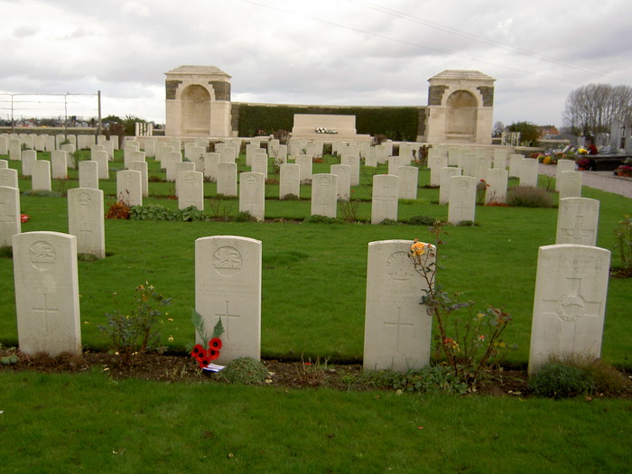
Estaires is a town and commune in the Department of the Nord, about 11 kilometres west of Armentieres. The Cemetery is on the eastern outskirts of the town and on the east side of the road to Bailleul. Leave the church and head north-east on the Avenue Kennedy. Take the second road on the left after 400 metres onto Rue de l'Egalite, which leads to the cemetery on the right hand side of the road. The Extension is on the far left hand side of the Communal Cemetery.
Estaires town was occupied by French cavalry on the 15 October 1914, and passed at once into British hands. On the 10 April 1918 it was captured by the enemy, after an obstinate defence by the 50th (Northumbrian) Division; and it was finally retaken by British troops at the beginning of September 1918. The town was a Field Ambulance centre as early as November 1914, and later the 1st Australian Casualty Clearing Station was posted in it. It was later "adopted" by the County Borough of Plymouth. Estaires Communal Cemetery was used for British burials from the early days of November 1914 to June 1917, and two burials of September 1918 are in Plot II, Row P. Estaires Communal Cemetery Extension was used from April 1917 to April 1918, and again in September-November 1918. The Plots are numbered IV and V, in continuation of the numbering for the Communal Cemetery. The Portuguese graves of June-August 1917 and two French graves were removed after the Armistice. A German Plot of 63 graves, made on the North side during the enemy occupation in 1918, has been removed.
There are a total of 875 Commonwealth burials of the First World War here, 63 of which are unidentified. There are 9 Commonwealth burials of World War II, killed during the withdrawal of the British Expeditionary Force to Dunkirk at the end of May 1940. There are also 14 non-Commonwealth burials in C.W.G.C. care. The five plots cover an area of 3336 square metres.
Nearby cemeteries

Estaires, Departement du Nord, Nord-Pas-de-Calais, France
- Total memorials259
- Percent photographed12%
- Percent with GPS1%

La Gorgue, Departement du Nord, Nord-Pas-de-Calais, France
- Total memorials152
- Percent photographed6%
- Percent with GPS0%

Sailly-sur-la-Lys, Departement du Pas-de-Calais, Nord-Pas-de-Calais, France
- Total memorials264
- Percent photographed21%
- Percent with GPS3%

Sailly-sur-la-Lys, Departement du Pas-de-Calais, Nord-Pas-de-Calais, France
- Total memorials316
- Percent photographed22%
- Percent with GPS4%
- Added: 1 Nov 2004
- Find a Grave Cemetery ID: 1997373

Cemetery Photos
This is a carousel with slides. Use Next and Previous buttons to navigate, or jump to a slide with the slide dots. Use Escape keyboard button or the Close button to close the carousel.

Success
Uploading...
Waiting...
Failed
This photo was not uploaded because this cemetery already has 20 photos
This photo was not uploaded because you have already uploaded 5 photos to this cemetery
This photo was not uploaded because you have already uploaded 5 photos to this cemetery
Invalid File Type
Birth and death years unknown.
1 photo picked...
2 photos picked...
Uploading 1 Photo
Uploading 2 Photos
1 Photo Uploaded
2 Photos Uploaded
Size exceeded
Too many photos have been uploaded
"Unsupported file type"
• ##count## of 0 memorials with GPS displayed. Double click on map to view more.No cemeteries found