Bowersock Cemetery
Also known as Decker Cemetery
Independence Township, Washington County, Ohio, USA
About
-
Get directions Shay Ridge Road (Township Road 604)
Independence Township, Washington County, Ohio 45768, USACoordinates: 39.47500, -81.24220 - Cemetery ID:
Members have Contributed
Advertisement
Photos
No additional photos.
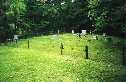
Add PhotosThe cemetery is located on the southwest side of Shay Ridge Road (Township Road 604) at its intersection with Archers Fork Road (County Road 14).
The cemetery is located in Independence Township, Washington County, Ohio, and is # 12436 (Bowersock Cemetery / Decker Cemetery) in "Ohio Cemeteries 1803-2003", compiled by the Ohio Genealogical Society.
The cemetery is registered with the Ohio Division of Real Estate and Professional Licensing (ODRE) as Decker with registration license number CGR.0000982936.
The U.S. Geological Survey (USGS) Geographic Names Information System (GNIS) feature ID for the cemetery is 1075429 (Bowersock Cemetery).
The cemetery is located on the southwest side of Shay Ridge Road (Township Road 604) at its intersection with Archers Fork Road (County Road 14).
The cemetery is located in Independence Township, Washington County, Ohio, and is # 12436 (Bowersock Cemetery / Decker Cemetery) in "Ohio Cemeteries 1803-2003", compiled by the Ohio Genealogical Society.
The cemetery is registered with the Ohio Division of Real Estate and Professional Licensing (ODRE) as Decker with registration license number CGR.0000982936.
The U.S. Geological Survey (USGS) Geographic Names Information System (GNIS) feature ID for the cemetery is 1075429 (Bowersock Cemetery).
Nearby cemeteries

Archers Fork, Washington County, Ohio, USA
- Total memorials250
- Percent photographed64%
- Percent with GPS6%

Lawrence Township, Washington County, Ohio, USA
- Total memorials270
- Percent photographed87%
- Percent with GPS3%

Washington County, Ohio, USA
- Total memorials10
- Percent photographed60%
- Percent with GPS0%
Archers Fork, Washington County, Ohio, USA
- Total memorials7
- Percent photographed0%
- Percent with GPS0%
- Added: 1 Jan 2000
- Find a Grave Cemetery ID: 39986

Cemetery Photos
This is a carousel with slides. Use Next and Previous buttons to navigate, or jump to a slide with the slide dots. Use Escape keyboard button or the Close button to close the carousel.
Success
Uploading...
Waiting...
Failed
This photo was not uploaded because this cemetery already has 20 photos
This photo was not uploaded because you have already uploaded 5 photos to this cemetery
This photo was not uploaded because you have already uploaded 5 photos to this cemetery
Invalid File Type
Birth and death years unknown.
1 photo picked...
2 photos picked...
Uploading 1 Photo
Uploading 2 Photos
1 Photo Uploaded
2 Photos Uploaded
Size exceeded
Too many photos have been uploaded
"Unsupported file type"
• ##count## of 0 memorials with GPS displayed. Double click on map to view more.No cemeteries found