Ypres Town Cemetery Extension
Ypres, Arrondissement Ieper, West Flanders, Belgium – *No GPS coordinates
About
-
No location information available
Add Location - Cemetery ID:
Members have Contributed
- 526 Memorials
- 48% photographed
- No location information available Add Location
Advertisement
Photos


Location Information: Ypres Town Cemetery Extension is located 1 kilometre east of Ieper town centre, on the Zonnebeekseweg (N332), connecting Ieper to Zonnebeke. From Ieper town centre the Zonnebeekseweg is located via Torhoutstraat and right onto Basculestraat. Basculestraat ends at a main cross roads and the first left hand turn is the Zonnebeekseweg (N345). The cemetery itself is located 300 metres along the Zonnebeekseweg on the right hand side of the road.
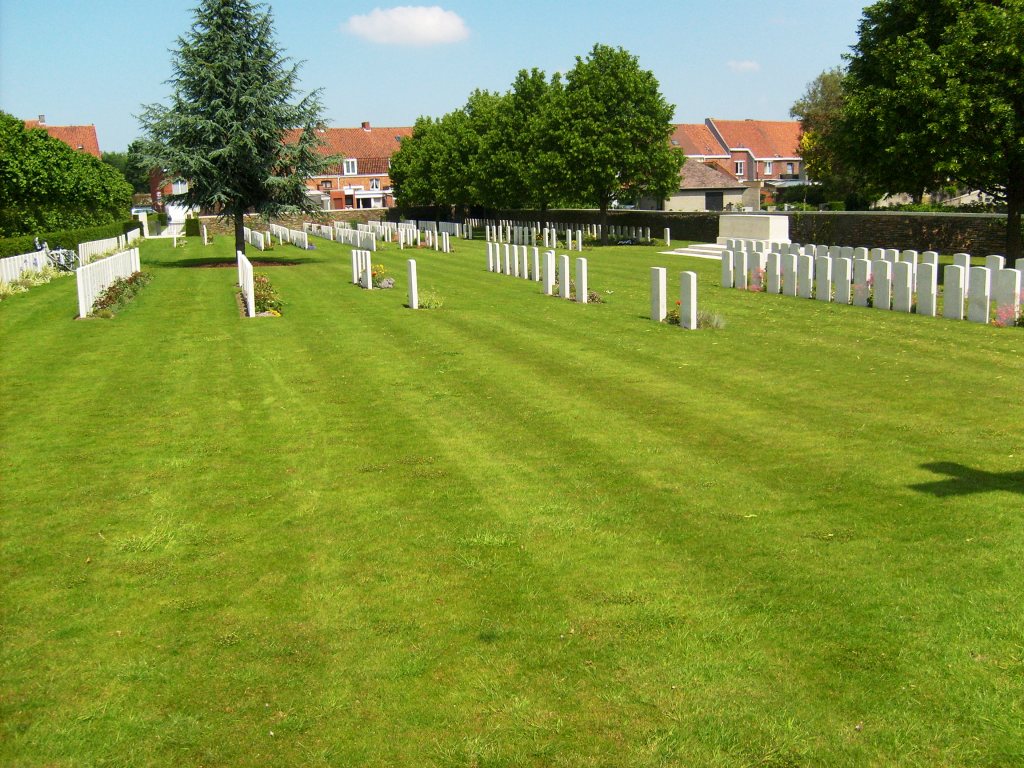
Historical Information: From October 1914 to the summer of 1918, Ypres (now Ieper) formed the centre of a salient held by Commonwealth (and for a while French) forces. From April 1915, the town was bombarded and destroyed more completely than any other town of its size on the western front. By the outbreak of the Second World War, Ypres had been completely rebuilt, but saw heavy fighting before it fell to the Germans on May 29, 1940. Ypres Town Cemetery, close to the Menin Gate, was used from October 1914 to May 1915, and once in 1918. The cemetery contains 145 Commonwealth burials of the First World War, grouped in plots among the civil graves. The Extension, on the east side of the town cemetery, was also begun in October 1914 and was used until April 1915, and on two further occasions in 1918. The extension was much increased after the Armistice when 367 graves were brought in from small cemeteries and isolated positions east and north of Ypres. During and after the fighting of May 1940, three civilian hospitals in the town, (Hopital de Notre Dame, the Clinique des Soeurs Noires and the Red Cross Hospital in St. Aloisius School, D'Hondstraat), cared for the wounded, and those who died were buried in the Town Cemetery Extension. Others buried on the battlefield were later brought in by the Ypres town services. There are now 598 Commonwealth casualties of the First World War buried or commemorated in the extension. 137 of the burials are unidentified and there are special memorials to 16 servicemen known or believed to be buried among them. Second World War burials number 43, of which 13 are unidentified. The extension was designed by Sir Reginald Blomfield.
No. of Identified Casualties: 508
Location Information: Ypres Town Cemetery Extension is located 1 kilometre east of Ieper town centre, on the Zonnebeekseweg (N332), connecting Ieper to Zonnebeke. From Ieper town centre the Zonnebeekseweg is located via Torhoutstraat and right onto Basculestraat. Basculestraat ends at a main cross roads and the first left hand turn is the Zonnebeekseweg (N345). The cemetery itself is located 300 metres along the Zonnebeekseweg on the right hand side of the road.
Historical Information: From October 1914 to the summer of 1918, Ypres (now Ieper) formed the centre of a salient held by Commonwealth (and for a while French) forces. From April 1915, the town was bombarded and destroyed more completely than any other town of its size on the western front. By the outbreak of the Second World War, Ypres had been completely rebuilt, but saw heavy fighting before it fell to the Germans on May 29, 1940. Ypres Town Cemetery, close to the Menin Gate, was used from October 1914 to May 1915, and once in 1918. The cemetery contains 145 Commonwealth burials of the First World War, grouped in plots among the civil graves. The Extension, on the east side of the town cemetery, was also begun in October 1914 and was used until April 1915, and on two further occasions in 1918. The extension was much increased after the Armistice when 367 graves were brought in from small cemeteries and isolated positions east and north of Ypres. During and after the fighting of May 1940, three civilian hospitals in the town, (Hopital de Notre Dame, the Clinique des Soeurs Noires and the Red Cross Hospital in St. Aloisius School, D'Hondstraat), cared for the wounded, and those who died were buried in the Town Cemetery Extension. Others buried on the battlefield were later brought in by the Ypres town services. There are now 598 Commonwealth casualties of the First World War buried or commemorated in the extension. 137 of the burials are unidentified and there are special memorials to 16 servicemen known or believed to be buried among them. Second World War burials number 43, of which 13 are unidentified. The extension was designed by Sir Reginald Blomfield.
No. of Identified Casualties: 508
Nearby cemeteries

Ypres, Arrondissement Ieper, West Flanders, Belgium
- Total memorials50k+
- Percent photographed86%
- Percent with GPS0%

Ypres, Arrondissement Ieper, West Flanders, Belgium
- Total memorials4k+
- Percent photographed75%
- Percent with GPS0%

Ypres, Arrondissement Ieper, West Flanders, Belgium
- Total memorials1k+
- Percent photographed85%
- Percent with GPS1%

Ypres, Arrondissement Ieper, West Flanders, Belgium
- Total memorials1k+
- Percent photographed53%
- Percent with GPS10%
- Added: 18 Dec 2005
- Find a Grave Cemetery ID: 2161167

Cemetery Photos
This is a carousel with slides. Use Next and Previous buttons to navigate, or jump to a slide with the slide dots. Use Escape keyboard button or the Close button to close the carousel.


Success
Uploading...
Waiting...
Failed
This photo was not uploaded because this cemetery already has 20 photos
This photo was not uploaded because you have already uploaded 5 photos to this cemetery
This photo was not uploaded because you have already uploaded 5 photos to this cemetery
Invalid File Type
Birth and death years unknown.
1 photo picked...
2 photos picked...
Uploading 1 Photo
Uploading 2 Photos
1 Photo Uploaded
2 Photos Uploaded
Size exceeded
Too many photos have been uploaded
"Unsupported file type"
• ##count## of 0 memorials with GPS displayed. Double click on map to view more.No cemeteries found