Kandahar Farm Cemetery
Nieuwkerke, Arrondissement Ieper, West Flanders, Belgium
About
-
- Cemetery ID:
Members have Contributed
Advertisement
Photos


Location Information: Kandahar Farm Cemetery is located 10.5 km south of Ieper town centre on the Niewkerkestraat (N314), a road leading from the N365 connecting Ieper to Wijtschate, Mesen and on to Armentieres. From Ieper town centre the Rijselsestraat runs from the market square, through the Lille Gate (Rijselpoort) and directly over the crossroads with the Ieper ring road. The road name then changes to the Rijselseweg. On reaching the town of Mesen the first right hand turning leads onto the Mesenstraat (N314), which carries on to Nieuwkerke, via the village of Wulvergem. The cemetery lies 1 km after passing through the village of Wulvergem, on the left hand side of Nieuwkerkestraat.
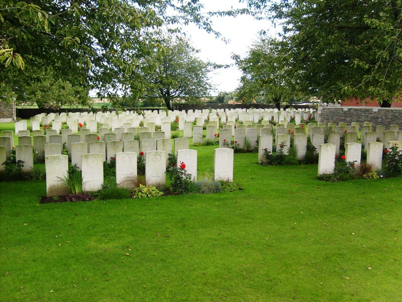
Historical Information: Kandahar Farm was near the village of Wulverghem (now Wulvergem) and for much of the war, the front line ran a little east of the village. The cemetery was used by Commonwealth divisions holding this sector from November 1914 to April 1918, when it fell into German hands with the capture of Wulverghem and Neuve-Eglise (now Nieuwkerke). The two villages were recovered in early September and the cemetery was used again. There are now 443 Commonwealth burials of the First World War in the cemetery. The cemetery was designed by Charles Holden.
No. of Identified Casualties: 435
Location Information: Kandahar Farm Cemetery is located 10.5 km south of Ieper town centre on the Niewkerkestraat (N314), a road leading from the N365 connecting Ieper to Wijtschate, Mesen and on to Armentieres. From Ieper town centre the Rijselsestraat runs from the market square, through the Lille Gate (Rijselpoort) and directly over the crossroads with the Ieper ring road. The road name then changes to the Rijselseweg. On reaching the town of Mesen the first right hand turning leads onto the Mesenstraat (N314), which carries on to Nieuwkerke, via the village of Wulvergem. The cemetery lies 1 km after passing through the village of Wulvergem, on the left hand side of Nieuwkerkestraat.
Historical Information: Kandahar Farm was near the village of Wulverghem (now Wulvergem) and for much of the war, the front line ran a little east of the village. The cemetery was used by Commonwealth divisions holding this sector from November 1914 to April 1918, when it fell into German hands with the capture of Wulverghem and Neuve-Eglise (now Nieuwkerke). The two villages were recovered in early September and the cemetery was used again. There are now 443 Commonwealth burials of the First World War in the cemetery. The cemetery was designed by Charles Holden.
No. of Identified Casualties: 435
Nearby cemeteries

Comines-Warneton, Arrondissement de Mouscron, Hainaut, Belgium
- Total memorials455
- Percent photographed100%
- Percent with GPS0%

Wulvergem, Arrondissement Ieper, West Flanders, Belgium
- Total memorials58
- Percent photographed97%
- Percent with GPS0%

Wulvergem, Arrondissement Ieper, West Flanders, Belgium
- Total memorials689
- Percent photographed92%
- Percent with GPS2%

Comines-Warneton, Arrondissement de Mouscron, Hainaut, Belgium
- Total memorials196
- Percent photographed97%
- Percent with GPS1%
- Added: 2 Dec 2005
- Find a Grave Cemetery ID: 2159884

Cemetery Photos
This is a carousel with slides. Use Next and Previous buttons to navigate, or jump to a slide with the slide dots. Use Escape keyboard button or the Close button to close the carousel.


Success
Uploading...
Waiting...
Failed
This photo was not uploaded because this cemetery already has 20 photos
This photo was not uploaded because you have already uploaded 5 photos to this cemetery
This photo was not uploaded because you have already uploaded 5 photos to this cemetery
Invalid File Type
Birth and death years unknown.
1 photo picked...
2 photos picked...
Uploading 1 Photo
Uploading 2 Photos
1 Photo Uploaded
2 Photos Uploaded
Size exceeded
Too many photos have been uploaded
"Unsupported file type"
• ##count## of 0 memorials with GPS displayed. Double click on map to view more.No cemeteries found