Saint Helen's Anglican Cemetery
Also known as Pinaymootang First Nation Cemetery , Fairford Reserve Cemetery
Fairford, North Interlake Census Division, Manitoba, Canada
About
-
Get directions Abraham Cowley Drive
Fairford, Pinaymootang First Nation, Manitoba
R0C 0X0 CanadaCoordinates: 51.60268, -98.69956 - rupertsland.ca/manitoba-north/st-helen
- [email protected]
- +1-204-659-5705
-
Office Address
St Helen Parish
PO Box 48
Hilbre, RM of Grahamdale, Manitoba
R0C 1L0 Canada - Cemetery ID:
-
Additional information
Located in the community of Fairford, MB, on the territory of the Pinaymootang First Nation, within the northern portion of the arc formed by Abraham Cowley Drive north of David Anderson Drive
A single minimally-maintained roadway provides nominal vehicular access to the grounds
Burial records can be consulted by contacting the Parish Secretary.
NOTE: It is possible the records for the new section mentioned above are only available from the office of the Pinaymootang First Nation
Members have Contributed
Advertisement


Fairford Mission was opened by Rev. (afterward Ven. Archdeacon) Cowley. His first visit was in the summer of 1842, when he came to arrange for its establishment. It then had only an Indian name, Penaymootang, or "Partridge Crop". The name Fairford was given to the place by the Rev. William Stagg who succeeded Mr. Cowley, naming if after his native place in Gloucestershire in England. In 1843 Mr. Cowley made Partridge Crop his permanent headquarters, building a church and a boarding school.
(This article on the early days of the Fairford area is believed to have been written by Mr. Dobbs, a lay minister and postmaster at Fairford in the early 1920s.)
(Source: North-West Interlake Heritage -- Moosehorn - Gypsumville, p 425 [1991; Adapted])
The history of those early days is a rich and interesting story. It was all virgin land, and around where Fairford was settled it was a beautiful forest. The rivers were clear, trees were plentiful, and there was an abundance of wildlife and fish. It was to this land that the Rev. Abraham Cowley and his wife came, and for some of the people living there, these were the first white people they had ever seen. Rev. Abraham Cowley and his wife were in the Fairford area from 1842-1854.
Rev. Cowley immediately put up two log buildings at one for their home, and the other to be used for a Church and a School. With the passage of time these buildings are no longer there, and the land where they stood is now ploughed.
Also, Fairford got it's name after Bishop David Anderson made a visit there in February 1851, - while it was still called "Partridge Crop, Pin-nay-moo-tung" — and he changed the name of the Mission to Fairford, in remembrance of the birthplace of Rev. Cowley.
From "The Anglican Church From The Bay to the Rockies", and with permission from McGraw-Hill Ryerson Ltd, I quote; "Mr. William Stagg was an Englishman. sent out by the Church Missionary Society. He succeeded Mr. Cowley at the difficult mission among the Saulteaux at Fairford. where he ministered for over eleven years. Fairford, during his ministry, became the centre from which missionary expeditions were sent out on the western plains, with the result that permanent stations were opened in the Touchwood Hills and at Fort Ellice, the latter close to the junction of the Qu'Appelle and Assiniboine rivers." End quote. Mr. Stagg was ordained June 29, 1854, and some of the place names we are more familiar with today, where work was carried on were: Staggville, Manitobah (Kinosota), Shoal River, Fort Pelly, and Duck Bay.
(Source: Many Trails to Manitou-Wapah, pp 26eff [1993; Adapted])
~~~~~~~~~~
Pinaymootang First Nations Community cemetery used to be the Fairford St Helen's Anglican church cemetery but it is now the community cemetery for the reserve's 3 churches: Anglican, Pentecostal and Apostolic, The older original cemetery is now filled and a new cemetery has been started south of the old one.
The Anglican church still stands in the old cemetery grounds while the Pentecostal and Apostolic churches are along the highway which runs through the reserve.
(Source: Manitoba Genealogical Society [Adapted])
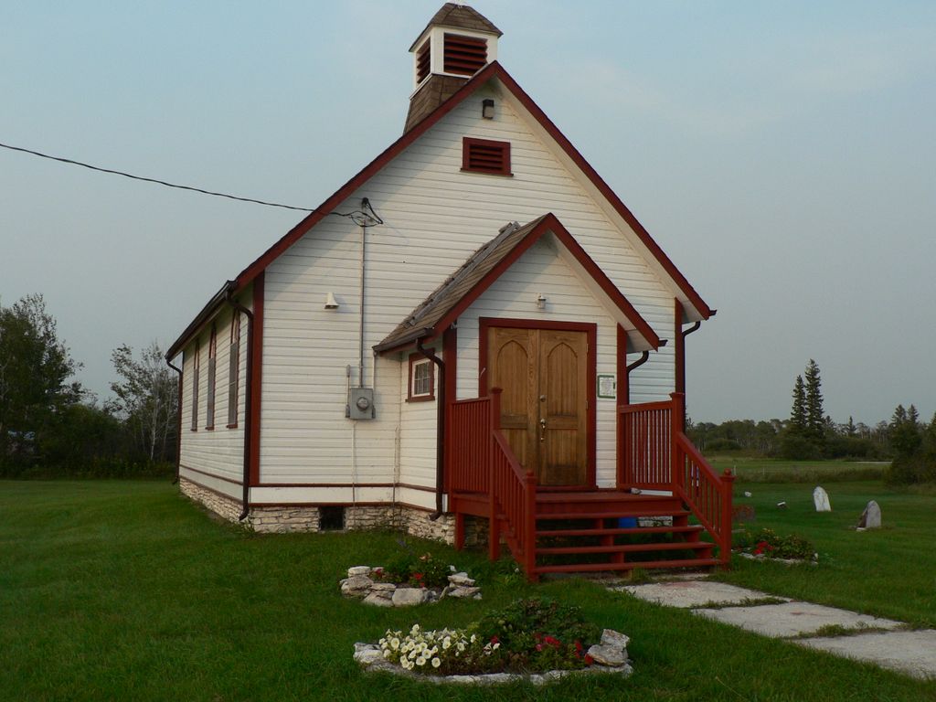
In 1842, Anglican cleric Abraham Cowley arrived at Fairford (in what what is now the Rural Municipality of Grahamdale) to establish an Anglican Church to serve the local Aboriginal people. The present St. Helen's Anglican Church, a municipally-designated historic site (2003), dates from 1911. Restoration was done as part of the Manitoba Prairie Churches Project.
Adjacent to the church are a pair of stone monuments. One was erected in 1971 to commemorate Richard Woodhouse (1837-1902), who was first elected Chief of the Fairford Reserve on 3 August 1871, and his sons who succeeded him, Richard Woodhouse and William Woodhouse. The other monument was erected in November 1948 to commemorate local people who served during the Second World War.
Among the clerics who served at St. Helen's was Edna Lenora Perry.
(Source: Manitoba Historical Society [Adapted])
~~~~~~~~~~
Dominion Land Survey coordinates: LSD12-29-30-09-W1
On the lands of the Pinaymootang First Nation
~~~~~~~~~~
As noted above, a part of this historically significant community's story, and those of its inhabitants, from the early days of European settlement through roughly 1993 is told in the volumes "North-West Interlake Heritage - Moosehorn Gypsumville" and "Many Trails to Manitou-Wapah", especially on the cited pages.
Free digital versions of these and many other Manitoba local history books can be found online in the University of Manitoba Digital Collections. There is also a list of such books organized by district and town name on the Manitoba Historical Society's website on their page entitled "Finding Aid: Manitoba Local History Books".
A list of burials in this cemetery is available from the Manitoba Genealogical Society (reference #1195), transcribed by a member or members in 1997. Also available to MGS members is a searchable online database named the "MGS Manitoba Name Index" (or MANI). Some additional information is contained in the 1996 MGS publication "Carved in Stone: Manitoba Cemeteries and Burial Sites" (revised edition, Special Projects Publication, 106 pages).
~~~~~~~~~~
NOTE: Many of the remaining markers are significantly deteriorated and are very difficult, if not impossible to read
Fairford Mission was opened by Rev. (afterward Ven. Archdeacon) Cowley. His first visit was in the summer of 1842, when he came to arrange for its establishment. It then had only an Indian name, Penaymootang, or "Partridge Crop". The name Fairford was given to the place by the Rev. William Stagg who succeeded Mr. Cowley, naming if after his native place in Gloucestershire in England. In 1843 Mr. Cowley made Partridge Crop his permanent headquarters, building a church and a boarding school.
(This article on the early days of the Fairford area is believed to have been written by Mr. Dobbs, a lay minister and postmaster at Fairford in the early 1920s.)
(Source: North-West Interlake Heritage -- Moosehorn - Gypsumville, p 425 [1991; Adapted])
The history of those early days is a rich and interesting story. It was all virgin land, and around where Fairford was settled it was a beautiful forest. The rivers were clear, trees were plentiful, and there was an abundance of wildlife and fish. It was to this land that the Rev. Abraham Cowley and his wife came, and for some of the people living there, these were the first white people they had ever seen. Rev. Abraham Cowley and his wife were in the Fairford area from 1842-1854.
Rev. Cowley immediately put up two log buildings at one for their home, and the other to be used for a Church and a School. With the passage of time these buildings are no longer there, and the land where they stood is now ploughed.
Also, Fairford got it's name after Bishop David Anderson made a visit there in February 1851, - while it was still called "Partridge Crop, Pin-nay-moo-tung" — and he changed the name of the Mission to Fairford, in remembrance of the birthplace of Rev. Cowley.
From "The Anglican Church From The Bay to the Rockies", and with permission from McGraw-Hill Ryerson Ltd, I quote; "Mr. William Stagg was an Englishman. sent out by the Church Missionary Society. He succeeded Mr. Cowley at the difficult mission among the Saulteaux at Fairford. where he ministered for over eleven years. Fairford, during his ministry, became the centre from which missionary expeditions were sent out on the western plains, with the result that permanent stations were opened in the Touchwood Hills and at Fort Ellice, the latter close to the junction of the Qu'Appelle and Assiniboine rivers." End quote. Mr. Stagg was ordained June 29, 1854, and some of the place names we are more familiar with today, where work was carried on were: Staggville, Manitobah (Kinosota), Shoal River, Fort Pelly, and Duck Bay.
(Source: Many Trails to Manitou-Wapah, pp 26eff [1993; Adapted])
~~~~~~~~~~
Pinaymootang First Nations Community cemetery used to be the Fairford St Helen's Anglican church cemetery but it is now the community cemetery for the reserve's 3 churches: Anglican, Pentecostal and Apostolic, The older original cemetery is now filled and a new cemetery has been started south of the old one.
The Anglican church still stands in the old cemetery grounds while the Pentecostal and Apostolic churches are along the highway which runs through the reserve.
(Source: Manitoba Genealogical Society [Adapted])
In 1842, Anglican cleric Abraham Cowley arrived at Fairford (in what what is now the Rural Municipality of Grahamdale) to establish an Anglican Church to serve the local Aboriginal people. The present St. Helen's Anglican Church, a municipally-designated historic site (2003), dates from 1911. Restoration was done as part of the Manitoba Prairie Churches Project.
Adjacent to the church are a pair of stone monuments. One was erected in 1971 to commemorate Richard Woodhouse (1837-1902), who was first elected Chief of the Fairford Reserve on 3 August 1871, and his sons who succeeded him, Richard Woodhouse and William Woodhouse. The other monument was erected in November 1948 to commemorate local people who served during the Second World War.
Among the clerics who served at St. Helen's was Edna Lenora Perry.
(Source: Manitoba Historical Society [Adapted])
~~~~~~~~~~
Dominion Land Survey coordinates: LSD12-29-30-09-W1
On the lands of the Pinaymootang First Nation
~~~~~~~~~~
As noted above, a part of this historically significant community's story, and those of its inhabitants, from the early days of European settlement through roughly 1993 is told in the volumes "North-West Interlake Heritage - Moosehorn Gypsumville" and "Many Trails to Manitou-Wapah", especially on the cited pages.
Free digital versions of these and many other Manitoba local history books can be found online in the University of Manitoba Digital Collections. There is also a list of such books organized by district and town name on the Manitoba Historical Society's website on their page entitled "Finding Aid: Manitoba Local History Books".
A list of burials in this cemetery is available from the Manitoba Genealogical Society (reference #1195), transcribed by a member or members in 1997. Also available to MGS members is a searchable online database named the "MGS Manitoba Name Index" (or MANI). Some additional information is contained in the 1996 MGS publication "Carved in Stone: Manitoba Cemeteries and Burial Sites" (revised edition, Special Projects Publication, 106 pages).
~~~~~~~~~~
NOTE: Many of the remaining markers are significantly deteriorated and are very difficult, if not impossible to read
Nearby cemeteries

Davis Point, North Interlake Census Division, Manitoba, Canada
- Total memorials27
- Percent photographed96%
- Percent with GPS0%
Little Saskatchewan, North Interlake Census Division, Manitoba, Canada
- Total memorials9
- Percent photographed0%

Saint-Martin, North Interlake Census Division, Manitoba, Canada
- Total memorials158
- Percent photographed97%
- Percent with GPS0%
Hilbre, North Interlake Census Division, Manitoba, Canada
- Total memorials32
- Percent photographed25%
- Percent with GPS0%
- Added: 24 Nov 2006
- Find a Grave Cemetery ID: 2197844

Cemetery Photos
This is a carousel with slides. Use Next and Previous buttons to navigate, or jump to a slide with the slide dots. Use Escape keyboard button or the Close button to close the carousel.


Success
Uploading...
Waiting...
Failed
This photo was not uploaded because this cemetery already has 20 photos
This photo was not uploaded because you have already uploaded 5 photos to this cemetery
This photo was not uploaded because you have already uploaded 5 photos to this cemetery
Invalid File Type
Birth and death years unknown.
1 photo picked...
2 photos picked...
Uploading 1 Photo
Uploading 2 Photos
1 Photo Uploaded
2 Photos Uploaded
Size exceeded
Too many photos have been uploaded
"Unsupported file type"
• ##count## of 0 memorials with GPS displayed. Double click on map to view more.No cemeteries found