African Cemetery
Key West, Monroe County, Florida, USA
About
-
Get directions Higgs Beach, White Street & Atlantic Blvd
Key West, Florida 33040 United StatesCoordinates: 24.54745, -81.78539 - Cemetery ID:
Members have Contributed
Advertisement
Photos


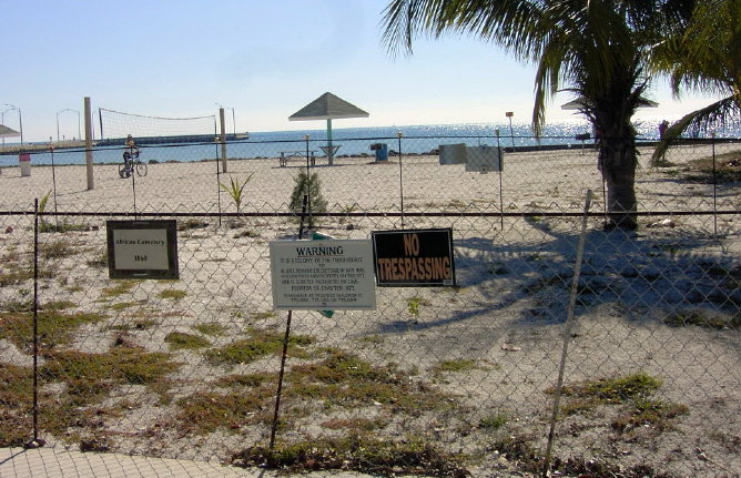
The African cemetery appears on an 1861 map drawn by the US Army Corps of Engineers located in an uninhabited tract of land, along the beach what is now called Higgs Beach. On the map, it is labeled "African Cemetery," with nine small X's to represent the location of the graves. Later, a Martello tower was constructed in the same location about the time of the Civil War.
According to maps, 295 graves were under the West Martello structure, and extended out onto the beach towards the East. Ground Penetrating Radar was used in an archaeological survey that tested the theory of the location. On the beach, approximately 40 feet from the fort walls, rows of grave-like features were found. At this location, 2 to 3 feet below the surface were a series of 5 to 6 foot long oval holes exactly where the African Cemetery was mapped in 1861. Nine of these are very clear, and another six are there, but not as well defined. These features are closely spaced, and form three rows. The images recorded of these features match exactly with other known gravesites found by using GPR.
There has now been constructed a memorial to those who died as a result of the conditions on the slave ships.
Nearby cemeteries

Key West, Monroe County, Florida, USA
- Total memorials18
- Percent photographed100%
- Percent with GPS100%
Key West, Monroe County, Florida, USA
- Total memorials1
- Percent photographed0%
- Percent with GPS0%

Key West, Monroe County, Florida, USA
- Total memorials115
- Percent photographed93%
- Percent with GPS3%

Key West, Monroe County, Florida, USA
- Total memorials15k+
- Percent photographed51%
- Percent with GPS19%
- Added: 29 May 2005
- Find a Grave Cemetery ID: 2144331

Cemetery Photos
This is a carousel with slides. Use Next and Previous buttons to navigate, or jump to a slide with the slide dots. Use Escape keyboard button or the Close button to close the carousel.


Success
Uploading...
Waiting...
Failed
This photo was not uploaded because this cemetery already has 20 photos
This photo was not uploaded because you have already uploaded 5 photos to this cemetery
This photo was not uploaded because you have already uploaded 5 photos to this cemetery
Invalid File Type
Birth and death years unknown.
1 photo picked...
2 photos picked...
Uploading 1 Photo
Uploading 2 Photos
1 Photo Uploaded
2 Photos Uploaded
Size exceeded
Too many photos have been uploaded
"Unsupported file type"
• ##count## of 0 memorials with GPS displayed. Double click on map to view more.No cemeteries found