Sylvan Grove Cemetery
Smith County, Mississippi, USA
About
-
Get directions Smith County Road 581B
null, Mississippi 39152 United StatesCoordinates: 32.11373, -89.45304 - Cemetery ID:
Members have Contributed
Advertisement
Photos


right (East.) Continue miles on SCR 120 4.75 miles and turn left (North) continuing for 1.6 miles to the intersection of Smith County Road 581-B (SCR 581-B) and turn right (East.) In approximately 125 feet, SCR 581-B splits into two roads going two different direction (SCR 581-B actually makes a circle in this are.) At this point, take the left (North) road. Continue 650 to 700 feet on the North branch of SCR 581-B until the intersection of US Forest Service Road 581-B (FSR 581-B.) This is a dirt road maintained by the US Forest Service, proceed straight ahead onto FSR 581-B and continue continue 850 feet, a grown over driveway will be visible on your right (East,) proceed up this drive to the cemetery (approximately 150 feet,) specifically: SE1/4 NW1/4, S11, T3N-R8E, Smith, Louin SW Quadrangle map, USNG: 16S BA 68552 55676.
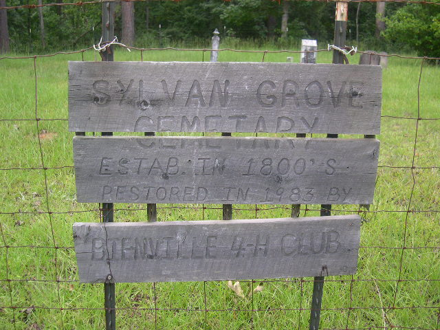
This cemetery was established sometime in the 1800s and was restored in 1983; however, it has since fallen into disrepair, with many of the remaining markers broken or damaged. A barbed wire fence is present around the cemetery. The driveway is overgrown and the cemetery appears to receive very little care.
right (East.) Continue miles on SCR 120 4.75 miles and turn left (North) continuing for 1.6 miles to the intersection of Smith County Road 581-B (SCR 581-B) and turn right (East.) In approximately 125 feet, SCR 581-B splits into two roads going two different direction (SCR 581-B actually makes a circle in this are.) At this point, take the left (North) road. Continue 650 to 700 feet on the North branch of SCR 581-B until the intersection of US Forest Service Road 581-B (FSR 581-B.) This is a dirt road maintained by the US Forest Service, proceed straight ahead onto FSR 581-B and continue continue 850 feet, a grown over driveway will be visible on your right (East,) proceed up this drive to the cemetery (approximately 150 feet,) specifically: SE1/4 NW1/4, S11, T3N-R8E, Smith, Louin SW Quadrangle map, USNG: 16S BA 68552 55676.
This cemetery was established sometime in the 1800s and was restored in 1983; however, it has since fallen into disrepair, with many of the remaining markers broken or damaged. A barbed wire fence is present around the cemetery. The driveway is overgrown and the cemetery appears to receive very little care.
Nearby cemeteries

Raleigh, Smith County, Mississippi, USA
- Total memorials56
- Percent photographed89%
- Percent with GPS7%

Smith County, Mississippi, USA
- Total memorials18
- Percent photographed67%
- Percent with GPS0%

Raleigh, Smith County, Mississippi, USA
- Total memorials62
- Percent photographed95%
- Percent with GPS0%

Raleigh, Smith County, Mississippi, USA
- Total memorials245
- Percent photographed93%
- Percent with GPS11%
- Added: 1 Jan 2000
- Find a Grave Cemetery ID: 63126

Cemetery Photos
This is a carousel with slides. Use Next and Previous buttons to navigate, or jump to a slide with the slide dots. Use Escape keyboard button or the Close button to close the carousel.


Success
Uploading...
Waiting...
Failed
This photo was not uploaded because this cemetery already has 20 photos
This photo was not uploaded because you have already uploaded 5 photos to this cemetery
This photo was not uploaded because you have already uploaded 5 photos to this cemetery
Invalid File Type
Birth and death years unknown.
1 photo picked...
2 photos picked...
Uploading 1 Photo
Uploading 2 Photos
1 Photo Uploaded
2 Photos Uploaded
Size exceeded
Too many photos have been uploaded
"Unsupported file type"
• ##count## of 0 memorials with GPS displayed. Double click on map to view more.No cemeteries found