St. Mary Rest Ground
Also known as Foxs Burial Ground
Nottingham, Nottingham Unitary Authority, Nottinghamshire, England
About
-
Get directions Saint Ann
Nottingham, Nottingham Unitary Authority, Nottinghamshire EnglandCoordinates: 52.95683, -1.14066 - Cemetery ID:
Members have Contributed
Advertisement
Photos
No additional photos.
Add PhotosSt. Mary's Rest Garden
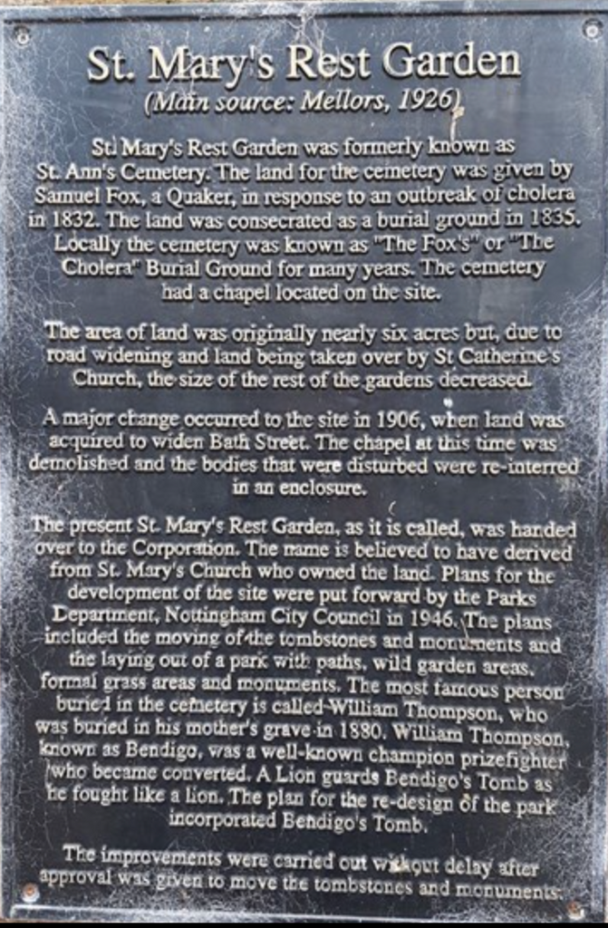
(Main Source: Mellors, 1926)
St. Mary's Rest Garden was formerly known as
St. Ann's Cemetery. The land for the cemetery was given by
Samuel Fox, A Quaker, in response to an outbreak of cholera
In 1832. The land was consecrated as a burial ground in 1835.
Locally the cemetery was known as "The Fox's" or "The
Cholera" Burial Ground for many years. The cemetery
had a chapel located on the site.
The area of land was originally nearly six acres but, due to
road widening and land being taken over by St Catherine's
Church, the size of the rest of the gardens decreased.
A Major change occurred to the site in 1906, when land was
acquired to widen Bath street. The chapel at this time was
demolished and the bodies that were disturbed were re-interred
In an enclosure.
The present St. Mary's Rest Garden, as it is called, was handed
over to the Corporation. The name is believed to have derived
from St. Mary's Church who owned the land. Plans for the
development of the site were put forward by the Parks
Department. Nottingham City Council in 1946. The plans
included the moving of the tombstones and monuments and
the laying out of a park with paths, wild garden areas,
formal grass area and monuments. The most famous person to be
buried in the cemetery is called William Thompson, who
was buried in his mother's grave in 1880. William Thompson,
known as Bendigo, was a well-known champion prizefighter
who became converted. A Lion guards Bendigo's Tomb as
he fought like a Lion. The plan for the re-design of the park
incorporated Bendigo's Tomb.
The improvements were carried out without delay after
Approval was given to move the tombstones and monuments.
St. Mary's Rest Garden
(Main Source: Mellors, 1926)
St. Mary's Rest Garden was formerly known as
St. Ann's Cemetery. The land for the cemetery was given by
Samuel Fox, A Quaker, in response to an outbreak of cholera
In 1832. The land was consecrated as a burial ground in 1835.
Locally the cemetery was known as "The Fox's" or "The
Cholera" Burial Ground for many years. The cemetery
had a chapel located on the site.
The area of land was originally nearly six acres but, due to
road widening and land being taken over by St Catherine's
Church, the size of the rest of the gardens decreased.
A Major change occurred to the site in 1906, when land was
acquired to widen Bath street. The chapel at this time was
demolished and the bodies that were disturbed were re-interred
In an enclosure.
The present St. Mary's Rest Garden, as it is called, was handed
over to the Corporation. The name is believed to have derived
from St. Mary's Church who owned the land. Plans for the
development of the site were put forward by the Parks
Department. Nottingham City Council in 1946. The plans
included the moving of the tombstones and monuments and
the laying out of a park with paths, wild garden areas,
formal grass area and monuments. The most famous person to be
buried in the cemetery is called William Thompson, who
was buried in his mother's grave in 1880. William Thompson,
known as Bendigo, was a well-known champion prizefighter
who became converted. A Lion guards Bendigo's Tomb as
he fought like a Lion. The plan for the re-design of the park
incorporated Bendigo's Tomb.
The improvements were carried out without delay after
Approval was given to move the tombstones and monuments.
Nearby cemeteries

Nottingham, Nottingham Unitary Authority, Nottinghamshire, England
- Total memorials68
- Percent photographed87%
- Percent with GPS71%

Nottingham, Nottingham Unitary Authority, Nottinghamshire, England
- Total memorials3
- Percent photographed100%
- Percent with GPS100%
Nottingham, Nottingham Unitary Authority, Nottinghamshire, England
- Total memorials1
- Percent photographed0%
- Percent with GPS0%

Sneinton, Nottingham Unitary Authority, Nottinghamshire, England
- Total memorials4k+
- Percent photographed1%
- Added: 22 Jul 2001
- Find a Grave Cemetery ID: 638762

Cemetery Photos
This is a carousel with slides. Use Next and Previous buttons to navigate, or jump to a slide with the slide dots. Use Escape keyboard button or the Close button to close the carousel.
Success
Uploading...
Waiting...
Failed
This photo was not uploaded because this cemetery already has 20 photos
This photo was not uploaded because you have already uploaded 5 photos to this cemetery
This photo was not uploaded because you have already uploaded 5 photos to this cemetery
Invalid File Type
Birth and death years unknown.
1 photo picked...
2 photos picked...
Uploading 1 Photo
Uploading 2 Photos
1 Photo Uploaded
2 Photos Uploaded
Size exceeded
Too many photos have been uploaded
"Unsupported file type"
• ##count## of 0 memorials with GPS displayed. Double click on map to view more.No cemeteries found