Duncan Family Cemetery
Millersburg, Callaway County, Missouri, USA
About
-
- Cemetery ID:
Members have Contributed
Advertisement
Photos


DIRECTIONS to cemetery:
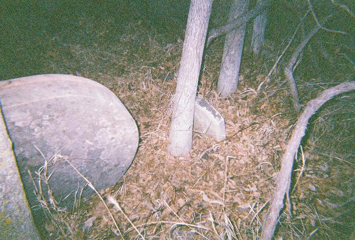
Starting at Millersburg Church (church sits on Hwy WW in Millersburg, Callaway Co., Missouri), go east on State Hwy J, follow highway until reaching Junction Hwy J & Hwy F, veer to the left following State Hwy F, continue following Hwy F until you reach County Rd 343, turn right (south) onto County Rd 343, this is a gravel road, go about 1 - 1 1/2 mile(s) down County Rd 343. The Duncan Family cemetery sits on the left side of the gravel road about 50 yards from the road, in a field. It sits inside of a fenced in area that is just big enough for the 3 graves that are there.
SOURCE: Judy K. Penley located grave site of Duncan Family Cemetery; 16 Mar 2003:
There are three (3) graves located there, the cemetery itself is located on the left side of the road, about 50 yards back in field. The old homestead used to stand in back of the graves, to the right of them, the house which was built by John Duncan was demolished in 1978. It is said that there is a grave of a slave on the property, it is located near the existing fence line, the name is unknown. The graves of the three (3) family members are located in a fenced area that is in very poor shape. There are many sapling trees growing there as well as full grown trees.
NOTE: This cemetery sits on private land, you should make arrangements with owner of property before visiting gravesite.
DIRECTIONS to cemetery:
Starting at Millersburg Church (church sits on Hwy WW in Millersburg, Callaway Co., Missouri), go east on State Hwy J, follow highway until reaching Junction Hwy J & Hwy F, veer to the left following State Hwy F, continue following Hwy F until you reach County Rd 343, turn right (south) onto County Rd 343, this is a gravel road, go about 1 - 1 1/2 mile(s) down County Rd 343. The Duncan Family cemetery sits on the left side of the gravel road about 50 yards from the road, in a field. It sits inside of a fenced in area that is just big enough for the 3 graves that are there.
SOURCE: Judy K. Penley located grave site of Duncan Family Cemetery; 16 Mar 2003:
There are three (3) graves located there, the cemetery itself is located on the left side of the road, about 50 yards back in field. The old homestead used to stand in back of the graves, to the right of them, the house which was built by John Duncan was demolished in 1978. It is said that there is a grave of a slave on the property, it is located near the existing fence line, the name is unknown. The graves of the three (3) family members are located in a fenced area that is in very poor shape. There are many sapling trees growing there as well as full grown trees.
NOTE: This cemetery sits on private land, you should make arrangements with owner of property before visiting gravesite.
Nearby cemeteries
Millersburg, Callaway County, Missouri, USA
- Total memorials13
- Percent photographed77%
- Percent with GPS0%

Fulton, Callaway County, Missouri, USA
- Total memorials567
- Percent photographed76%
- Percent with GPS1%

Millersburg, Callaway County, Missouri, USA
- Total memorials378
- Percent photographed89%
- Percent with GPS0%

Millersburg, Callaway County, Missouri, USA
- Total memorials1k+
- Percent photographed90%
- Percent with GPS87%
- Added: 7 Sep 2005
- Find a Grave Cemetery ID: 2152928

Cemetery Photos
This is a carousel with slides. Use Next and Previous buttons to navigate, or jump to a slide with the slide dots. Use Escape keyboard button or the Close button to close the carousel.


Success
Uploading...
Waiting...
Failed
This photo was not uploaded because this cemetery already has 20 photos
This photo was not uploaded because you have already uploaded 5 photos to this cemetery
This photo was not uploaded because you have already uploaded 5 photos to this cemetery
Invalid File Type
Birth and death years unknown.
1 photo picked...
2 photos picked...
Uploading 1 Photo
Uploading 2 Photos
1 Photo Uploaded
2 Photos Uploaded
Size exceeded
Too many photos have been uploaded
"Unsupported file type"
• ##count## of 0 memorials with GPS displayed. Double click on map to view more.No cemeteries found