Governor Joseph Jencks Lot
Also known as Rhode Island Historical Cemetery Pawtucket #9
Pawtucket, Providence County, Rhode Island, USA
About
-
Get directions High Street
Pawtucket, Rhode Island 02860 United StatesCoordinates: 41.87903, -71.38317 - Cemetery ID:
Members have Contributed
Advertisement
Photos

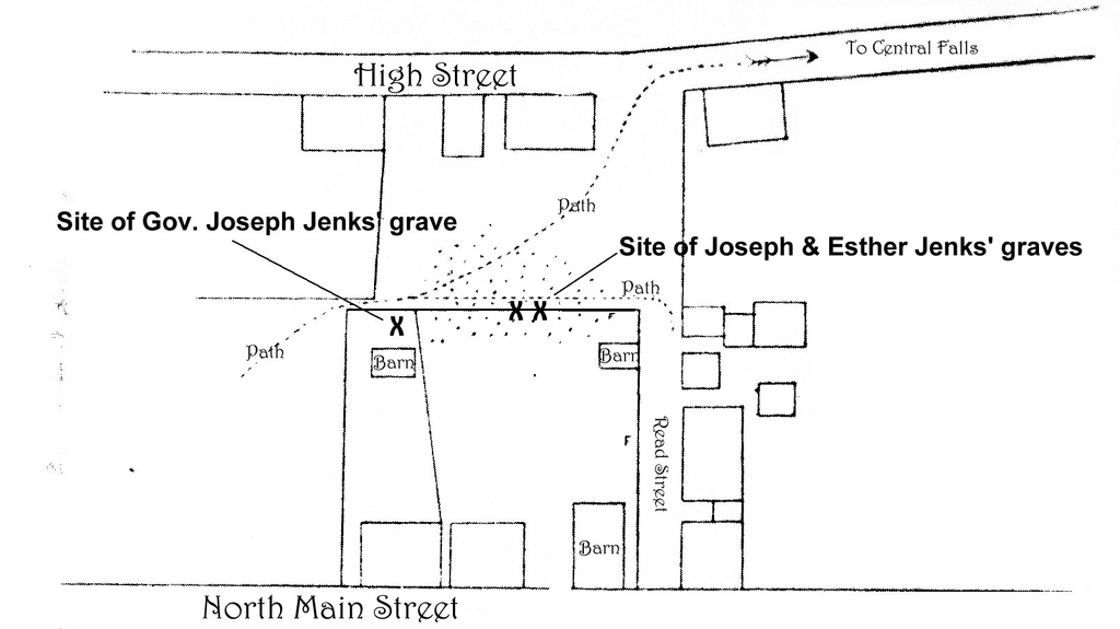
The Jencks family selected a 165 ft. square lot to lay their beloved to rest on Broken Back Hill, at that time a pleasant setting overlooking the river. The first burials were probably Joseph Jenks, the founder of Pawtucket, and his wife Esther Ballard in 1717. It remained in active use until the establishment of Mineral Spring Cemetery in 1774. The final recorded burial was Jonathan Jenks in 1781. After time the burial ground was heavily vandalized and it had apparently completely disappeared by 1894, when William Phinney, one of the older citizens of the Pawtucket, wrote an article for the Pawtucket Gazette & Chronicle about his recollections of the cemetery, which he had lived adjacent to as a child. He recalled that there were about sixty slate stones with angels' heads carved on the face. At that time they were badly leaning, broken and defaced. Mr. Phinney drew a plat of the burying ground indicating the surrounding buildings and the major grave locations including those of Joseph Jenks Sr. and his wife and Governor Joseph Jenks. Then in June of 1925, five gravestones and human remains were unearthed during excavation for construction of a garage on a lot between the Allen House on Read St., the Masonic Temple on High St., and behind the Capt. Ellis House on Roosevelt Ave. The first stone examined was that of Joseph Jenckes, Colonial Governor of Rhode Island 1727-1732. It was one of two slabs used to cover a well behind the Allen House. There were four other stones discovered that day: Martha [Brown] Jenks, Lydia Jenks, William Jenckes, Esq., the foot stone of Governor Joseph Jenks, and an unidentified stone.
The map location is approximate.
Nearby cemeteries

Pawtucket, Providence County, Rhode Island, USA
- Total memorials3k+
- Percent photographed88%
- Percent with GPS0%

Pawtucket, Providence County, Rhode Island, USA
- Total memorials2k+
- Percent photographed84%
- Percent with GPS0%

Pawtucket, Providence County, Rhode Island, USA
- Total memorials8k+
- Percent photographed79%
- Percent with GPS8%

Pawtucket, Providence County, Rhode Island, USA
- Total memorials7k+
- Percent photographed41%
- Percent with GPS17%
- Added: 17 May 2007
- Find a Grave Cemetery ID: 2217412

Cemetery Photos
This is a carousel with slides. Use Next and Previous buttons to navigate, or jump to a slide with the slide dots. Use Escape keyboard button or the Close button to close the carousel.

Success
Uploading...
Waiting...
Failed
This photo was not uploaded because this cemetery already has 20 photos
This photo was not uploaded because you have already uploaded 5 photos to this cemetery
This photo was not uploaded because you have already uploaded 5 photos to this cemetery
Invalid File Type
Birth and death years unknown.
1 photo picked...
2 photos picked...
Uploading 1 Photo
Uploading 2 Photos
1 Photo Uploaded
2 Photos Uploaded
Size exceeded
Too many photos have been uploaded
"Unsupported file type"
• ##count## of 0 memorials with GPS displayed. Double click on map to view more.No cemeteries found