Trout-Miller Cemetery
Roanoke, Roanoke City, Virginia, USA
About
-
Get directions Cherryhill Road NW
Roanoke, Virginia 24017 United StatesCoordinates: 37.27784, -80.00613 - Cemetery ID:
Members have Contributed
Advertisement
Photos

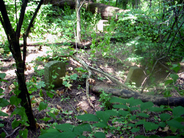
The TROUT-MILLER Cemetery is generally located about .3 mile southeast of the intersection of Peters Creek Road NW (SR 117), and Shenandoah Avenue (SR 742). Turn south off of Shenandoah Avenue onto Cherryhill Road, proceed south about 500 feet, then just past the intersection with a stub of Cherryhill Road, there is a short cement driveway to the west; the cemetery is about 300 feet down the steep wooded hillside to the east (opposite) of this driveway, and is perhaps halfway down the slope between the road and Peters Creek.
There appear to be no trails leading to the cemetery and the hillside is very overgrown. Do not attempt the steep climb down to the cemetery unless you are physically fit.
The small cemetery is enclosed by a low brick wall which had once been capped with roofing tiles. Sadly, the cemetery is now heavily vandalized, with many stones badly broken, and at least three graves recently dug out. Additionally, there is natural damage by fallen trees. Only about 7 stones are fully intact. Many shards of gravestones remain scattered on ground, and with some patience, some might be re-assembled on the ground for reading.
This very early cemetery is desperately in need of stabilization and some tender loving care.
Craig H. Trout
Loudoun County, VA
Nearby cemeteries
Roanoke, Roanoke City, Virginia, USA
- Total memorials2
- Percent photographed0%
- Percent with GPS0%

Roanoke, Roanoke City, Virginia, USA
- Total memorials2k+
- Percent photographed90%
- Percent with GPS86%

Roanoke, Roanoke City, Virginia, USA
- Total memorials9k+
- Percent photographed78%
- Percent with GPS76%

Roanoke, Roanoke City, Virginia, USA
- Total memorials15k+
- Percent photographed72%
- Percent with GPS19%
- Added: 16 Apr 2010
- Find a Grave Cemetery ID: 2350671

Cemetery Photos
This is a carousel with slides. Use Next and Previous buttons to navigate, or jump to a slide with the slide dots. Use Escape keyboard button or the Close button to close the carousel.

Success
Uploading...
Waiting...
Failed
This photo was not uploaded because this cemetery already has 20 photos
This photo was not uploaded because you have already uploaded 5 photos to this cemetery
This photo was not uploaded because you have already uploaded 5 photos to this cemetery
Invalid File Type
Birth and death years unknown.
1 photo picked...
2 photos picked...
Uploading 1 Photo
Uploading 2 Photos
1 Photo Uploaded
2 Photos Uploaded
Size exceeded
Too many photos have been uploaded
"Unsupported file type"
• ##count## of 0 memorials with GPS displayed. Double click on map to view more.No cemeteries found